IMAGES TAKEN NEAR TO
Nidderdale, HULL, HU7 4BS
Introduction
This page details the photographs taken nearby to Nidderdale, HU7 4BS by members of the Geograph project.
The Geograph project started in 2005 with the aim of publishing, organising and preserving representative images for every square kilometre of Great Britain, Ireland and the Isle of Man.

There are currently over 7.5m images from over14,400 individuals and you can help contribute to the project by visiting https://www.geograph.org.uk
Image Map
Images are licensed for reuse under creativecommons.org/licenses/by-sa/2.0
Notes
- Clicking on the map will re-center to the selected point.
- The higher the marker number, the further away the image location is from the centre of the postcode.
Image Listing (66 Images Found)
Images are licensed for reuse under creativecommons.org/licenses/by-sa/2.0
Image
Details
Distance
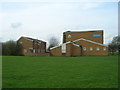
1
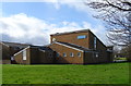
St Mary, Queen of Martyrs Catholic Church, Hull
On Nidderdale, Bransholme.
Image: © JThomas
Taken: 9 Mar 2019
0.00 miles
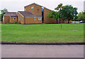
3

St. Mary, Queen of Martyrs R.C. church
In an oddly isolated position.
Built 1976. Architect: J Reid.
Image: © Jonathan Thacker
Taken: 7 May 2016
0.01 miles
8
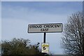
Stroud Crescent East, Hull
https://www.geograph.org.uk/photo/6798825
Image: © Ian S
Taken: 29 Mar 2021
0.06 miles
9
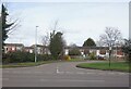
Stroud Crescent East, Hull
https://www.geograph.org.uk/photo/6798828
Image: © Ian S
Taken: 29 Mar 2021
0.07 miles
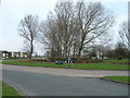
10
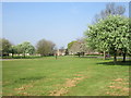
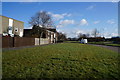
Blossom on the Bransholme Estate
A grassed area near the Roman Catholic church.
Image: © Jonathan Thacker
Taken: 7 May 2016
0.07 miles