IMAGES TAKEN NEAR TO
2nd Avenue, HULL, HU6 9NS
Introduction
This page details the photographs taken nearby to 2nd Avenue, HU6 9NS by members of the Geograph project.
The Geograph project started in 2005 with the aim of publishing, organising and preserving representative images for every square kilometre of Great Britain, Ireland and the Isle of Man.

There are currently over 7.5m images from over14,400 individuals and you can help contribute to the project by visiting https://www.geograph.org.uk
Image Map
Images are licensed for reuse under creativecommons.org/licenses/by-sa/2.0
Notes
- Clicking on the map will re-center to the selected point.
- The higher the marker number, the further away the image location is from the centre of the postcode.
Image Listing (154 Images Found)
Images are licensed for reuse under creativecommons.org/licenses/by-sa/2.0
Image
Details
Distance
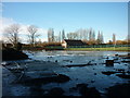
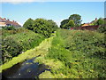
2
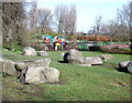
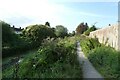
Princess Elizabeth Playing Fields
Looking north-northwest across the play area between the 2nd Avenue entrance and the Beverley & Barmston Drain.
Image: © Paul Glazzard
Taken: 29 Mar 2008
0.03 miles
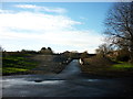
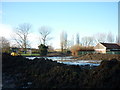
3
The Beverley and Barmston Drain
View north west from the bridge on Greenwood Avenue.
Image: © JThomas
Taken: 9 Mar 2019
0.04 miles
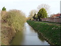
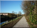
4
Path beside Beverley and Burnmanston Drain
The path forms part of National Cycle Network route 66.
Image: © DS Pugh
Taken: 2 Sep 2023
0.05 miles
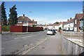
7
2nd Avenue, Hull
https://www.geograph.org.uk/photo/6815545
Image: © Ian S
Taken: 29 Mar 2021
0.06 miles
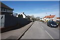
9
6th Avenue, Hull
https://www.geograph.org.uk/photo/6815518
Image: © Ian S
Taken: 29 Mar 2021
0.06 miles