IMAGES TAKEN NEAR TO
Beverley Road, HULL, HU6 9NJ
Introduction
This page details the photographs taken nearby to Beverley Road, HU6 9NJ by members of the Geograph project.
The Geograph project started in 2005 with the aim of publishing, organising and preserving representative images for every square kilometre of Great Britain, Ireland and the Isle of Man.

There are currently over 7.5m images from over14,400 individuals and you can help contribute to the project by visiting https://www.geograph.org.uk
Image Map
Images are licensed for reuse under creativecommons.org/licenses/by-sa/2.0
Notes
- Clicking on the map will re-center to the selected point.
- The higher the marker number, the further away the image location is from the centre of the postcode.
Image Listing (149 Images Found)
Images are licensed for reuse under creativecommons.org/licenses/by-sa/2.0
Image
Details
Distance
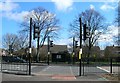
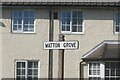
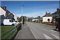
4
Watton Grove, Hull
https://www.geograph.org.uk/photo/6814773
Image: © Ian S
Taken: 29 Mar 2021
0.04 miles
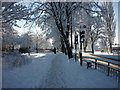
5
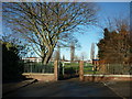
Entering Princess Elizabeth Playing Fields, Hull
Image: © Ian S
Taken: 4 Dec 2012
0.04 miles
6
Watton Grove, Hull
https://www.geograph.org.uk/photo/6814772
Image: © Ian S
Taken: 29 Mar 2021
0.05 miles
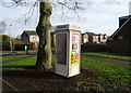
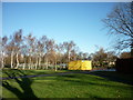
9
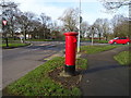
Emmott Road, Hull
Showing position of Postbox No. HU6 141.
See Image] for postbox.
Image: © JThomas
Taken: 9 Mar 2019
0.06 miles
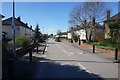
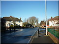
10
Lissett Grove, Hull
https://www.geograph.org.uk/photo/6815507
Image: © Ian S
Taken: 29 Mar 2021
0.06 miles