IMAGES TAKEN NEAR TO
National Avenue, HULL, HU5 4GE
Introduction
This page details the photographs taken nearby to National Avenue, HU5 4GE by members of the Geograph project.
The Geograph project started in 2005 with the aim of publishing, organising and preserving representative images for every square kilometre of Great Britain, Ireland and the Isle of Man.

There are currently over 7.5m images from over14,400 individuals and you can help contribute to the project by visiting https://www.geograph.org.uk
Image Map
Images are licensed for reuse under creativecommons.org/licenses/by-sa/2.0
Notes
- Clicking on the map will re-center to the selected point.
- The higher the marker number, the further away the image location is from the centre of the postcode.
Image Listing (81 Images Found)
Images are licensed for reuse under creativecommons.org/licenses/by-sa/2.0
Image
Details
Distance
2
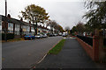
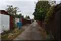
Haverflatts Close off Wises Farm Road, Hull
https://www.geograph.org.uk/photo/6843047
Image: © Ian S
Taken: 16 May 2021
0.02 miles
3

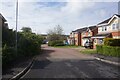
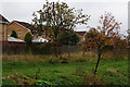
Haverflatts Close off Wises Farm Road, Hull
https://www.geograph.org.uk/photo/6843045
Image: © Ian S
Taken: 16 May 2021
0.03 miles
4
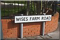
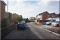
Wises Farm Road, Hull
https://www.geograph.org.uk/photo/6842917
Image: © Ian S
Taken: 16 May 2021
0.03 miles
5

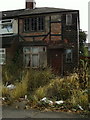
Wises Farm Road, Hull
https://www.geograph.org.uk/photo/6842921
Image: © Ian S
Taken: 16 May 2021
0.04 miles

10
Woolsheds Close off Wises Farm Road, Hull
https://www.geograph.org.uk/photo/6843051
Image: © Ian S
Taken: 16 May 2021
0.05 miles