IMAGES TAKEN NEAR TO
Harland Way, COTTINGHAM, HU16 5SZ
Introduction
This page details the photographs taken nearby to Harland Way, HU16 5SZ by members of the Geograph project.
The Geograph project started in 2005 with the aim of publishing, organising and preserving representative images for every square kilometre of Great Britain, Ireland and the Isle of Man.

There are currently over 7.5m images from over14,400 individuals and you can help contribute to the project by visiting https://www.geograph.org.uk
Image Map
Images are licensed for reuse under creativecommons.org/licenses/by-sa/2.0
Notes
- Clicking on the map will re-center to the selected point.
- The higher the marker number, the further away the image location is from the centre of the postcode.
Image Listing (13 Images Found)
Images are licensed for reuse under creativecommons.org/licenses/by-sa/2.0
Image
Details
Distance
1
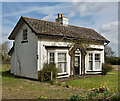
The White Cottage, off Harland Way, Cottingham
Once part of the extensive Browsholme Park, based around Browsholme, a 19-room mansion built in around 1877 for William Tall on land formerly known as ‘Harland’, once part of Cottingham’s ancient woodland. William Tall was a Hull oil and seed broker, and this cottage was built for his carriageman. The main house was demolished in 1964.
The cottage is due to be demolished in order to build nearly 90 new homes. Large numbers of mature trees have already been felled on the site in readiness for the building work.
Image: © Paul Harrop
Taken: 24 Mar 2021
0.15 miles
3

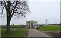
Keldgate Reservoir
The eastern most of the two covered reservoirs just outside Cottingham
Image: © Nigel Mykura
Taken: 24 Aug 2008
0.18 miles
4
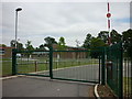
A walk to Cottingham #58
Cottingham High School.
Image: © Ian S
Taken: 16 Aug 2010
0.19 miles
5
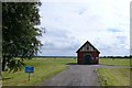
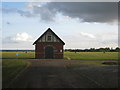
Keldgate Reservoir, Cottingham
A pair of covered reservoirs just outside the village, this is one of the old pumping houses.
Image: © Nigel Mykura
Taken: 24 Aug 2008
0.20 miles
6
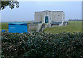
Keldgate Reservoir
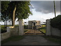
Yorkshire Water Building on Keldgate Road, Cottingham.
Image: © Ian S
Taken: 11 Jan 2017
0.21 miles
7

A walk to Cottingham #59
Harland Way, Cottingham.
Image: © Ian S
Taken: 16 Aug 2010
0.22 miles
8
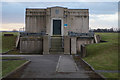
Keldgate Reservoir, Cottingham
The pumping house with the date of 1935 above the door also carries the Hull crest, suggesting that the facility was originally owned by the city rather than Yorkshire Water, as now.
Image: © Paul Harrop
Taken: 13 Oct 2007
0.22 miles