IMAGES TAKEN NEAR TO
Dene Road, COTTINGHAM, HU16 5PD
Introduction
This page details the photographs taken nearby to Dene Road, HU16 5PD by members of the Geograph project.
The Geograph project started in 2005 with the aim of publishing, organising and preserving representative images for every square kilometre of Great Britain, Ireland and the Isle of Man.

There are currently over 7.5m images from over14,400 individuals and you can help contribute to the project by visiting https://www.geograph.org.uk
Image Map
Images are licensed for reuse under creativecommons.org/licenses/by-sa/2.0
Notes
- Clicking on the map will re-center to the selected point.
- The higher the marker number, the further away the image location is from the centre of the postcode.
Image Listing (81 Images Found)
Images are licensed for reuse under creativecommons.org/licenses/by-sa/2.0
Image
Details
Distance
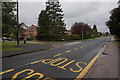
1
Dene Road, Cottingham
Looking east from the junction of Parkside Close.
Image: © Paul Glazzard
Taken: 10 Jul 2008
0.05 miles
3
Dene Woods, Cottingham
A small area of woodland between the residential Dene Road and Eppleworth Road.
Image: © Paul Harrop
Taken: 17 May 2008
0.06 miles
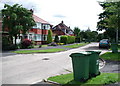
4

Houses in Westfield Road
Typical of this part of Cottingham.
Image: © Jonathan Thacker
Taken: 23 Dec 2015
0.07 miles

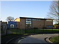
8

Dene Road from the bend in West End Road
Cross square, but showing a residential street
Image: © Martin Dawes
Taken: 30 Apr 2018
0.08 miles
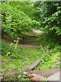
9

The Dene, Cottingham
Entrance to the small patch of woodland near the junction of Dene Road and Eppleworth Road.
Image: © Paul Glazzard
Taken: 10 Jul 2008
0.08 miles