IMAGES TAKEN NEAR TO
Mill Lane, BROUGH, HU15 2UW
Introduction
This page details the photographs taken nearby to Mill Lane, HU15 2UW by members of the Geograph project.
The Geograph project started in 2005 with the aim of publishing, organising and preserving representative images for every square kilometre of Great Britain, Ireland and the Isle of Man.

There are currently over 7.5m images from over14,400 individuals and you can help contribute to the project by visiting https://www.geograph.org.uk
Image Map
Images are licensed for reuse under creativecommons.org/licenses/by-sa/2.0
Notes
- Clicking on the map will re-center to the selected point.
- The higher the marker number, the further away the image location is from the centre of the postcode.
Image Listing (17 Images Found)
Images are licensed for reuse under creativecommons.org/licenses/by-sa/2.0
Image
Details
Distance
1
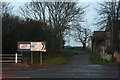
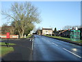
Arriving at the B1230 in Gilberdyke, from Staddlethorpe
Image: © Chris
Taken: 21 Dec 2013
0.03 miles
3
Elizabeth II postbox on Thornton Dam Lane, Gilberdyke
Image: © JThomas
Taken: 26 Jan 2018
0.11 miles
4
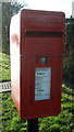
Close up, Elizabeth II postbox on Thornton Dam Lane, Gilberdyke
Postbox No. HU15 164.
See Image] for wider view.
Image: © JThomas
Taken: 26 Jan 2018
0.11 miles
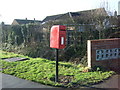
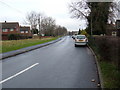
5
Thornton Dam Lane, Gilberdyke
Showing position of Postbox No. HU15 164.
See Image] for postbox.
Image: © JThomas
Taken: 26 Jan 2018
0.11 miles
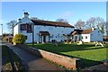
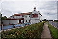
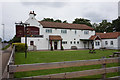
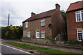
10
The White Horse Inn
A pub in Gilberdyke, East Yorkshire.
Image: © Ian S
Taken: 30 Jul 2010
0.17 miles