IMAGES TAKEN NEAR TO
Main Road, BROUGH, HU15 2SW
Introduction
This page details the photographs taken nearby to Main Road, HU15 2SW by members of the Geograph project.
The Geograph project started in 2005 with the aim of publishing, organising and preserving representative images for every square kilometre of Great Britain, Ireland and the Isle of Man.

There are currently over 7.5m images from over14,400 individuals and you can help contribute to the project by visiting https://www.geograph.org.uk
Image Map
Images are licensed for reuse under creativecommons.org/licenses/by-sa/2.0
Notes
- Clicking on the map will re-center to the selected point.
- The higher the marker number, the further away the image location is from the centre of the postcode.
Image Listing (17 Images Found)
Images are licensed for reuse under creativecommons.org/licenses/by-sa/2.0
Image
Details
Distance
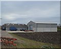
1
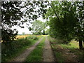
Track off Main Road
Is also officially a public footpath to Bennetland Lane.
Image: © Jonathan Thacker
Taken: 30 Aug 2015
0.10 miles
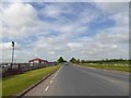

7
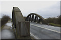
Slipper Bridge, Gilberdyke
Carrying the B1230 over the Hull to Selby railway line
Image: © Paul Harrop
Taken: 3 Apr 2010
0.20 miles
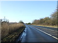
9
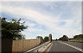
Slipper Bridge west of Gilberdyke
This carries the B1230 over the Hull to Selby railway line
Image: © Martin Dawes
Taken: 3 Jul 2015
0.24 miles
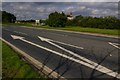
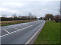
10
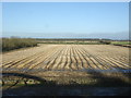
Stubble field near Gilberdyke
View from Slipper Bridge.
Image: © JThomas
Taken: 26 Jan 2018
0.24 miles