IMAGES TAKEN NEAR TO
Manor Road, BROUGH, HU15 2NE
Introduction
This page details the photographs taken nearby to Manor Road, HU15 2NE by members of the Geograph project.
The Geograph project started in 2005 with the aim of publishing, organising and preserving representative images for every square kilometre of Great Britain, Ireland and the Isle of Man.

There are currently over 7.5m images from over14,400 individuals and you can help contribute to the project by visiting https://www.geograph.org.uk
Image Map
Images are licensed for reuse under creativecommons.org/licenses/by-sa/2.0
Notes
- Clicking on the map will re-center to the selected point.
- The higher the marker number, the further away the image location is from the centre of the postcode.
Image Listing (47 Images Found)
Images are licensed for reuse under creativecommons.org/licenses/by-sa/2.0
Image
Details
Distance
1

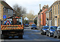
Blossom's Lane, North Cave
Living up to its name.
Image: © Christine Johnstone
Taken: 14 Apr 2023
0.06 miles
2

The west end of Nordham, North Cave
This street is shown as 'Nordam' on the large-scale OS map surveyed in 1852.
Image: © Christine Johnstone
Taken: 14 Oct 2022
0.10 miles
3
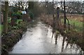
![North Cave Beck, looking east [upstream]](https://s3.geograph.org.uk/geophotos/07/46/61/7466199_119a2999_120x120.jpg)
North Cave Beck, looking east [upstream]
From the Blossom Lane bridge. A chalk stream with its headwaters on the scarp of the Yorkshire Wolds.
Image: © Christine Johnstone
Taken: 14 Apr 2023
0.11 miles
4
![North Cave Beck, looking downstream [west]](https://s2.geograph.org.uk/geophotos/07/46/61/7466198_f7ce5d3c_120x120.jpg)
North Cave Beck, looking downstream [west]
From the Blossom Lane bridge. A chalk stream with its headwaters on the scarp of the Yorkshire Wolds.
Image: © Christine Johnstone
Taken: 14 Apr 2023
0.11 miles
6

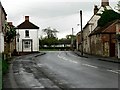
Signpost at the northern edge of North Cave
With directions to Hotham, North Cliffe and South Cliffe, Nordham and North Cave.
Image: © Christine Johnstone
Taken: 14 Oct 2022
0.15 miles
7
Church Street, North Cave
A no through road leading to housing and farms.
Image: © Pauline E
Taken: 27 Feb 2015
0.15 miles
8

Nordham, North Cave, looking eastwards
This street is shown as 'Nordam' on the large-scale OS map surveyed in 1852.
Image: © Christine Johnstone
Taken: 14 Oct 2022
0.15 miles
10
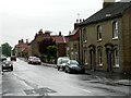
Westgate, North Cave
Looking towards the T Junction to North Cave Church, left, and South Cave, right
Image: © Roger Gilbertson
Taken: 22 May 2006
0.16 miles