IMAGES TAKEN NEAR TO
Robson Way, HULL, HU12 8XQ
Introduction
This page details the photographs taken nearby to Robson Way, HU12 8XQ by members of the Geograph project.
The Geograph project started in 2005 with the aim of publishing, organising and preserving representative images for every square kilometre of Great Britain, Ireland and the Isle of Man.

There are currently over 7.5m images from over14,400 individuals and you can help contribute to the project by visiting https://www.geograph.org.uk
Image Map
Images are licensed for reuse under creativecommons.org/licenses/by-sa/2.0
Notes
- Clicking on the map will re-center to the selected point.
- The higher the marker number, the further away the image location is from the centre of the postcode.
Image Listing (78 Images Found)
Images are licensed for reuse under creativecommons.org/licenses/by-sa/2.0
Image
Details
Distance
1
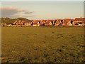
The old Hedon Aerodrome Field
This was the second of the four locations I cycled to yesterday - each one a corner of the square TA1828. This was looking into the square south eastwards from TA18002900. Unfortunately, two of the positions yielded unusable images at TA19002900 where I could only have looked into somebody's living room and at TA19902800 where the view was just a hedge at the other side of the road! The four visits took 46 minutes and by the time I got home, I'd travelled about 4.7 miles. I was wondering whether this would be the first time in Geograph's history where a single square's four extremities had been visited in such short succession!
Image: © Andy Beecroft
Taken: 16 May 2020
0.10 miles

3
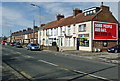
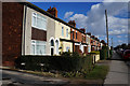
Hull Road, Preston
Just west of the Hedon town boundary, these houses are on the north side of Hull Road.
Image: © Paul Harrop
Taken: 12 Mar 2008
0.10 miles
4
A walk to Preston. #1
The start of my walk to Preston. Hull road, Hedon.
Image: © Ian S
Taken: 22 Jul 2010
0.10 miles
5
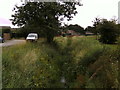
Drainage in Hedon
After several days of rain this drain is nearly at the limit of its capacity.
Image: © Peter Church
Taken: 22 Jan 2008
0.11 miles
7
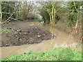
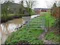
Footpath and Drain, Hedon
The drain was quite high following persistent heavy rain over several days. The footpath required wellington boots. This water eventually reaches the Humber via Salt End.
Image: © Peter Church
Taken: 22 Jan 2008
0.11 miles
8
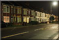
Houses on New Road, Preston (South)
I managed to find a 'window' where it wasn't raining in Hedon. The wet road adds to the atmosphere of the photo. Superficially part of Hedon, this western end of the town is in the parish of Preston South - a village one and a half miles north of here.
Image: © Andy Beecroft
Taken: 23 Nov 2019
0.11 miles
9
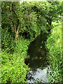
A Hedon drainage channel
This drainage channel forms the boundary between Hedon and Preston South.
Image: © Andy Beecroft
Taken: 10 Jul 2008
0.11 miles
10

The Road to Hull
I managed to find a 'window' where it wasn't raining in Hedon. The wet road adds to the atmosphere of the photo. Superficially part of Hedon, this western end of the town is in the parish of Preston South - a village one and a half miles north of here.
Image: © Andy Beecroft
Taken: 23 Nov 2019
0.11 miles