IMAGES TAKEN NEAR TO
Manor Park, HULL, HU12 8XE
Introduction
This page details the photographs taken nearby to Manor Park, HU12 8XE by members of the Geograph project.
The Geograph project started in 2005 with the aim of publishing, organising and preserving representative images for every square kilometre of Great Britain, Ireland and the Isle of Man.

There are currently over 7.5m images from over14,400 individuals and you can help contribute to the project by visiting https://www.geograph.org.uk
Image Map
Images are licensed for reuse under creativecommons.org/licenses/by-sa/2.0
Notes
- Clicking on the map will re-center to the selected point.
- The higher the marker number, the further away the image location is from the centre of the postcode.
Image Listing (36 Images Found)
Images are licensed for reuse under creativecommons.org/licenses/by-sa/2.0
Image
Details
Distance
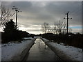
1
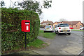
Elizabeth II postbox on Weghill Road, Preston
Image: © JThomas
Taken: 11 Jan 2020
0.08 miles
2
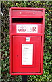
Close up, Elizabeth II postbox on Weghill Road, Preston
Postbox No. HU12 283.
See Image] for wider view.
Image: © JThomas
Taken: 11 Jan 2020
0.08 miles
3

Addison Road, Preston
Showing position of Postbox No. HU12 283.
See Image] for postbox.
Image: © JThomas
Taken: 11 Jan 2020
0.10 miles
4
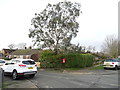
Addison Road, Preston
Showing position of Postbox No. HU12 283.
See Image] for postbox.
Image: © JThomas
Taken: 11 Jan 2020
0.10 miles
5
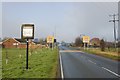
Entering Preston (E Yorks)
The village welcome and boundary/speed limit signs on Weghill Road.
Image: © Paul Harrop
Taken: 1 Mar 2014
0.15 miles
6

School Road, Preston, Yorkshire
At the junction with Weghill Road, 'The Bede Houses', terrace of four dwellings, School Road, built by 1852.
A Bede House was a type of almshouse run to a set of strict rules, typically run by a church. Bede is OE or Saxon for priest. Each Bedesman (or woman) was given a daily allowance of one penny plus a weekly or monthly allotment of clothing and fuel, for which they lived by a timetable of prayer and manual work.
Image: © Bernard Sharp
Taken: 19 Sep 2014
0.16 miles
8
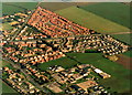
Weghill Road, Preston
Taken from outside TA1930 but showing the housing within this square. Preston's population was increased substantially from the 1970s onwards with the building of these three housing estates. South Holderness School can be seen in the bottom right of the photograph.
Image: © Andy Beecroft
Taken: Unknown
0.17 miles
9

School Road, Preston, Yorkshire
At the junction with East End Road, No.33 School Road, a focal point in the village.
Image: © Bernard Sharp
Taken: 17 Jul 2014
0.17 miles
10

School Road, Preston, Yorkshire
The foundation stone set in the façade of No.31 School Road reads: 'Rose Cottage 1872 JM'.
Image: © Bernard Sharp
Taken: 17 Jul 2014
0.17 miles