IMAGES TAKEN NEAR TO
School Road, HULL, HU12 8UG
Introduction
This page details the photographs taken nearby to School Road, HU12 8UG by members of the Geograph project.
The Geograph project started in 2005 with the aim of publishing, organising and preserving representative images for every square kilometre of Great Britain, Ireland and the Isle of Man.

There are currently over 7.5m images from over14,400 individuals and you can help contribute to the project by visiting https://www.geograph.org.uk
Image Map
Images are licensed for reuse under creativecommons.org/licenses/by-sa/2.0
Notes
- Clicking on the map will re-center to the selected point.
- The higher the marker number, the further away the image location is from the centre of the postcode.
Image Listing (127 Images Found)
Images are licensed for reuse under creativecommons.org/licenses/by-sa/2.0
Image
Details
Distance
1

School Road, Preston, Yorkshire
The foundation stone set in the façade of No.31 School Road reads: 'Rose Cottage 1872 JM'.
Image: © Bernard Sharp
Taken: 17 Jul 2014
0.00 miles
2

School Road, Preston, Yorkshire
At the junction with East End Road, No.33 School Road, a focal point in the village.
Image: © Bernard Sharp
Taken: 17 Jul 2014
0.00 miles
3

School Road, Preston, Yorkshire
Preston House, No.27 School Road, is described in the Council's Conservation Area Appraisal as an "unlisted building of interest, 18th and early 19th century with later alterations". The front elevation is almost entirely obscured by mature trees in the large front garden. The house is best viewed from Rectory Lane, where the rear and side elevations are largely unobscured. Note that there is no rear garden.
Image: © Bernard Sharp
Taken: 17 Jul 2014
0.02 miles
4

School Road, Preston, Yorkshire
At the junction with Weghill Road, 'The Bede Houses', terrace of four dwellings, School Road, built by 1852.
A Bede House was a type of almshouse run to a set of strict rules, typically run by a church. Bede is OE or Saxon for priest. Each Bedesman (or woman) was given a daily allowance of one penny plus a weekly or monthly allotment of clothing and fuel, for which they lived by a timetable of prayer and manual work.
Image: © Bernard Sharp
Taken: 19 Sep 2014
0.03 miles
5
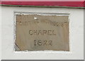
Date stone for former Primitive Methodist Chapel, Preston
See Image] for context.
Image: © JThomas
Taken: 11 Jan 2020
0.03 miles
6

School Road, Preston, Yorkshire
The foundation stone on the Rectory Lane elevation of No.19 School Road reads: 'Primitive Methodist Chapel 1822'. The chapel was rebuilt 1867 before it was superseded by new premises in Station Road in 1898. By 1990, the redundant chapel was North's Fisheries; today it is Grand Ruby, a Chinese take-away.
Image: © Bernard Sharp
Taken: 17 Jul 2014
0.03 miles
7
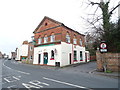
Former Primitive Methodist Chapel, Preston
Now a food takeaway.
Dated 1822.
Image: © JThomas
Taken: 11 Jan 2020
0.03 miles

9
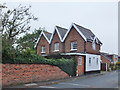
Rectory Lane, Preston, Yorkshire
The Gables, house, No.1 Rectory Lane.
Image: © Bernard Sharp
Taken: 19 Sep 2014
0.05 miles
10

School Road, Preston, Yorkshire
Terrace of three dwellings at Nos.13 to 17 School Road, late 19th century. The single-storey building, far left, designated No.13A, was converted from a shop to residential use in 1993; it and No.13 would appear to be a single entity.
Image: © Bernard Sharp
Taken: 17 Jul 2014
0.05 miles