IMAGES TAKEN NEAR TO
Prospect Lane, HULL, HU11 4UB
Introduction
This page details the photographs taken nearby to Prospect Lane, HU11 4UB by members of the Geograph project.
The Geograph project started in 2005 with the aim of publishing, organising and preserving representative images for every square kilometre of Great Britain, Ireland and the Isle of Man.

There are currently over 7.5m images from over14,400 individuals and you can help contribute to the project by visiting https://www.geograph.org.uk
Image Map
Images are licensed for reuse under creativecommons.org/licenses/by-sa/2.0
Notes
- Clicking on the map will re-center to the selected point.
- The higher the marker number, the further away the image location is from the centre of the postcode.
Image Listing (64 Images Found)
Images are licensed for reuse under creativecommons.org/licenses/by-sa/2.0
Image
Details
Distance
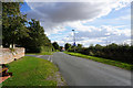
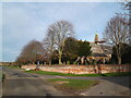
2
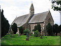
St. Albans, Withernwick
Withernwick sits in just about the centre of the grid square. This area is farmland.
Image: © Stephen Horncastle
Taken: 27 Aug 2005
0.06 miles
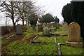
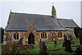
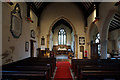
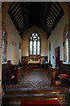
4
St Alban's Parish Church Withernwick
Rebuilt in 1855 by Mallinson & Healey incorporating old materials from a previous church
Image: © Martin Dawes
Taken: 21 Sep 2021
0.07 miles
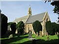
7
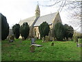
St Alban's Church and part of its burial ground, Withernwick
Viewed from the east.
Image: © Peter Wood
Taken: 5 Mar 2024
0.07 miles