IMAGES TAKEN NEAR TO
Redland Drive, HULL, HU10 7UX
Introduction
This page details the photographs taken nearby to Redland Drive, HU10 7UX by members of the Geograph project.
The Geograph project started in 2005 with the aim of publishing, organising and preserving representative images for every square kilometre of Great Britain, Ireland and the Isle of Man.

There are currently over 7.5m images from over14,400 individuals and you can help contribute to the project by visiting https://www.geograph.org.uk
Image Map
Images are licensed for reuse under creativecommons.org/licenses/by-sa/2.0
Notes
- Clicking on the map will re-center to the selected point.
- The higher the marker number, the further away the image location is from the centre of the postcode.
Image Listing (85 Images Found)
Images are licensed for reuse under creativecommons.org/licenses/by-sa/2.0
Image
Details
Distance
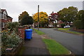
5
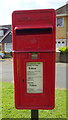
Close up, Elizabeth II postbox on Annandale Road, Kirk Ella
Postbox No. HU10 6.
See Image] for wider view.
Image: © JThomas
Taken: 9 Apr 2019
0.10 miles
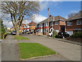
6
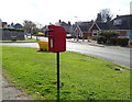
Elizabeth II postbox on Annandale Road, Kirk Ella
Image: © JThomas
Taken: 9 Apr 2019
0.10 miles
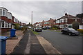
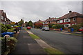
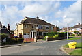
8
Houses on Annandale Road, Kirk Ella
Showing position of Postbox No. HU10 6.
See Image] for postbox.
Image: © JThomas
Taken: 9 Apr 2019
0.11 miles
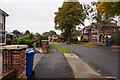
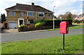
10
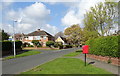
Annandale Road, Kirk Ella
Showing position of Postbox No. HU10 6.
See Image] for postbox.
Image: © JThomas
Taken: 9 Apr 2019
0.13 miles