IMAGES TAKEN NEAR TO
Fairfield Avenue, HULL, HU10 7UQ
Introduction
This page details the photographs taken nearby to Fairfield Avenue, HU10 7UQ by members of the Geograph project.
The Geograph project started in 2005 with the aim of publishing, organising and preserving representative images for every square kilometre of Great Britain, Ireland and the Isle of Man.

There are currently over 7.5m images from over14,400 individuals and you can help contribute to the project by visiting https://www.geograph.org.uk
Image Map
Images are licensed for reuse under creativecommons.org/licenses/by-sa/2.0
Notes
- Clicking on the map will re-center to the selected point.
- The higher the marker number, the further away the image location is from the centre of the postcode.
Image Listing (64 Images Found)
Images are licensed for reuse under creativecommons.org/licenses/by-sa/2.0
Image
Details
Distance
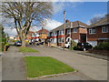
2

Looking down the B1232 from Oaklands Drive, Willerby
Image: © Chris
Taken: 2 Oct 2016
0.09 miles
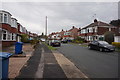
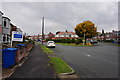
4
Oaklands Drive
Off Beverley Road (B1232).
Image: © Gerald England
Taken: 14 Apr 2019
0.11 miles
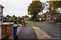
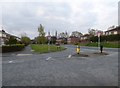
5

West Hill
A new housing development off the B1232.
Image: © Gerald England
Taken: 14 Apr 2019
0.12 miles
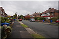
7
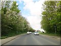
Beverley Road Willerby toward the A164
This section of road to the next roundabout has housing on both sides now the last fields are being built on at this time
Image: © Martin Dawes
Taken: 29 Apr 2018
0.13 miles