IMAGES TAKEN NEAR TO
Packman Lane, HULL, HU10 7TJ
Introduction
This page details the photographs taken nearby to Packman Lane, HU10 7TJ by members of the Geograph project.
The Geograph project started in 2005 with the aim of publishing, organising and preserving representative images for every square kilometre of Great Britain, Ireland and the Isle of Man.

There are currently over 7.5m images from over14,400 individuals and you can help contribute to the project by visiting https://www.geograph.org.uk
Image Map
Images are licensed for reuse under creativecommons.org/licenses/by-sa/2.0
Notes
- Clicking on the map will re-center to the selected point.
- The higher the marker number, the further away the image location is from the centre of the postcode.
Image Listing (70 Images Found)
Images are licensed for reuse under creativecommons.org/licenses/by-sa/2.0
Image
Details
Distance
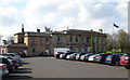
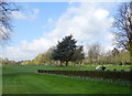
3
Hull Golf Club, Kirk Ella
Kirk Ella Hall, which is also the clubhouse, can be seen behind the trees in the right of the picture.
Image: © Paul Harrop
Taken: 4 Feb 2008
0.09 miles
4
Godmans Lane, Kirk Ella
Looking east-northeast towards St Andrew's Church.
Image: © Paul Glazzard
Taken: 9 Oct 2008
0.11 miles

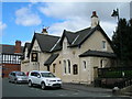
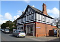
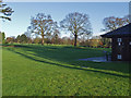
6

Former Village School
On Packman Lane, Kirk Ella.
Image: © Ian S
Taken: 14 Oct 2016
0.11 miles
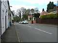
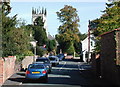
7

Godmans Lane, Kirk Ella
Looking towards the junction with Packman Lane, with the tower of St Andrew's Church in the distance.
Image: © Paul Harrop
Taken: 18 Feb 2023
0.12 miles