IMAGES TAKEN NEAR TO
West Ella Road, HULL, HU10 7QT
Introduction
This page details the photographs taken nearby to West Ella Road, HU10 7QT by members of the Geograph project.
The Geograph project started in 2005 with the aim of publishing, organising and preserving representative images for every square kilometre of Great Britain, Ireland and the Isle of Man.

There are currently over 7.5m images from over14,400 individuals and you can help contribute to the project by visiting https://www.geograph.org.uk
Image Map
Images are licensed for reuse under creativecommons.org/licenses/by-sa/2.0
Notes
- Clicking on the map will re-center to the selected point.
- The higher the marker number, the further away the image location is from the centre of the postcode.
Image Listing (58 Images Found)
Images are licensed for reuse under creativecommons.org/licenses/by-sa/2.0
Image
Details
Distance
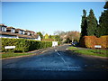
4
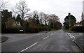
West Ella Road
Taken at Image looking eastwards.
Image: © Andy Beecroft
Taken: 22 Feb 2006
0.06 miles
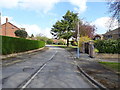
5
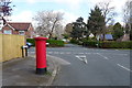
Valley Drive, Kirk Ella
Junction with West Ella Road.
Showing position of Postbox No. HU10 195.
See Image] for postbox.
Image: © JThomas
Taken: 9 Apr 2019
0.08 miles
6
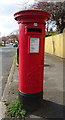
George VI postbox on Valley Drive, Kirk Ella
Image: © JThomas
Taken: 9 Apr 2019
0.08 miles
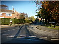
7
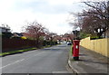
Valley Drive, Kirk Ella
Showing position of Postbox No. HU10 195.
See Image] for postbox.
Image: © JThomas
Taken: 9 Apr 2019
0.09 miles
8
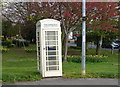
K6 telephone box on West Ella Road, Kirk Ella
Image: © JThomas
Taken: 9 Apr 2019
0.12 miles
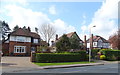
9
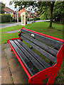
Bench and phone box, Kirk Ella
On the green area at the corner of School Lane and West Ella Road
Image: © Paul Harrop
Taken: 6 Jul 2021
0.12 miles