IMAGES TAKEN NEAR TO
Beverley Road, HULL, HU10 7HA
Introduction
This page details the photographs taken nearby to Beverley Road, HU10 7HA by members of the Geograph project.
The Geograph project started in 2005 with the aim of publishing, organising and preserving representative images for every square kilometre of Great Britain, Ireland and the Isle of Man.

There are currently over 7.5m images from over14,400 individuals and you can help contribute to the project by visiting https://www.geograph.org.uk
Image Map
Images are licensed for reuse under creativecommons.org/licenses/by-sa/2.0
Notes
- Clicking on the map will re-center to the selected point.
- The higher the marker number, the further away the image location is from the centre of the postcode.
Image Listing (51 Images Found)
Images are licensed for reuse under creativecommons.org/licenses/by-sa/2.0
Image
Details
Distance
2
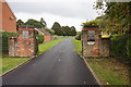
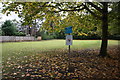
Entrance to King George V Playing Field, Anlaby
Image: © Ian S
Taken: 14 Oct 2016
0.06 miles

5
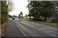
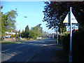
Beverley Road Kirk Ella
The houses on the left have driveways bridging Western Drain
Image: © Martin Dawes
Taken: 29 Apr 2018
0.08 miles
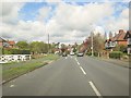
7
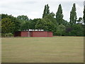
A walk from Hessle Square #16
Playing fields on Gorton Road.
Image: © Ian S
Taken: 11 Aug 2010
0.09 miles
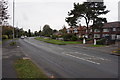
8
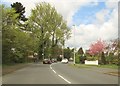
Beverley Road into Kirk Ella
The village sign is on the left, although the villages have been swamped by Hull they still all retain their identity
Image: © Martin Dawes
Taken: 29 Apr 2018
0.11 miles
9
Davis Corner Adit
Yorkshire Water Land off Beverley Road, Kirk Ella.
Image: © Ian S
Taken: 14 Oct 2016
0.12 miles
10
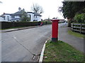
South Ella Drive, Kirk Ella
Showing position of Postbox No. HU10 162.
See Image] for postbox.
Image: © JThomas
Taken: 9 Apr 2019
0.14 miles