IMAGES TAKEN NEAR TO
Beech Lawn, HULL, HU10 7BN
Introduction
This page details the photographs taken nearby to Beech Lawn, HU10 7BN by members of the Geograph project.
The Geograph project started in 2005 with the aim of publishing, organising and preserving representative images for every square kilometre of Great Britain, Ireland and the Isle of Man.

There are currently over 7.5m images from over14,400 individuals and you can help contribute to the project by visiting https://www.geograph.org.uk
Image Map
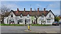
Images are licensed for reuse under creativecommons.org/licenses/by-sa/2.0
Notes
- Clicking on the map will re-center to the selected point.
- The higher the marker number, the further away the image location is from the centre of the postcode.
Image Listing (109 Images Found)
Images are licensed for reuse under creativecommons.org/licenses/by-sa/2.0
Image
Details
Distance
1

Wilson Street, Anlaby, Yorkshire
To the rear of No.27 Wilson Street are two dwellings at Nos.23 & 25 Wilson Street. Estate agents' literature describe No.23, left, as a period house; No.25 a cottage. The modern extensions to the older house appear to have been built on the site of the former Reading Room, said to have been located to the rear of the former chapel at No.27. Traces of a former gable can be seen on the older house above the modern extension.
Image: © Bernard Sharp
Taken: 20 Mar 2019
0.07 miles
2
Wilson Street, Anlaby, Yorkshire
Facing Hull Road, a terrace of shops at Nos.1 to 11 Wilson Street. A subsequent extension has been built at the left, numbered No.1A. In 1911, the terrace comprised private houses, with the exception of Nos.9 & 11, being a grocer's shop and house.
Image: © Bernard Sharp
Taken: 20 Mar 2019
0.07 miles
3
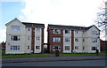
Blocks of flats on Lowfield Road, Anlaby
Lowfield Court and Lowfield House.
Image: © JThomas
Taken: 9 Apr 2019
0.08 miles
4
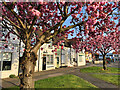
Wilson Street, Anlaby
Row of shops at the junction with Hull Road, briefly enlivened by a spring display of cherry blossom. The (now closed) Red Lion pub, and the Red Lion Court shop units are in the distance.
Image: © Paul Harrop
Taken: 22 Apr 2022
0.08 miles
5
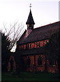
St. Peter's Church, Anlaby
Catching the last few rays of sun on a December afternoon. Looking northwest from the corner of Wilson Street and Church Street.
Image: © Paul Glazzard
Taken: 11 Dec 2006
0.08 miles
6
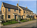
New houses in Anlaby
This short terrace on Wilson Street, along with a number of larger houses on the adjacent Crowle Close, were built in around 2017/2018, replacing long-derelict properties and their adjoining overgrown land on the southern side of the street.
Image: © Paul Harrop
Taken: 22 Apr 2022
0.08 miles
7
Wilson Street, Anlaby, Yorkshire
A Red Lion Inn was situated here by 1852. The present public house at No.13 Wilson Street probably dates from the 1930s.
Image: © Bernard Sharp
Taken: 20 Mar 2019
0.08 miles
8
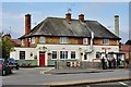
The Crofters, Anlaby
The Crofters is a restaurant serving traditional english cuisine, and very good quality it is too.
Image: © Peter Church
Taken: 16 Jul 2008
0.08 miles

10

Wilson Street, Anlaby, Yorkshire
The former Primitive Methodist chapel, No.27 Wilson Street, was built 1863. It replaced an older chapel which, according to the 1852 O.S. map, located it on the south side of nearby Ringrose Lane, now occupied by modern housing. No.27 is today occupied by East Riding Archaeology, a private business.
Image: © Bernard Sharp
Taken: 20 Mar 2019
0.09 miles