1
Church of Jesus Christ of Latter-Day Saints
On Springfield Way, Anlaby.
Image: © Ian S
Taken: 14 Oct 2016
0.05 miles
2
Missing merchant, Anlaby
Former Keyline builders' merchants on Springfield Way. The branch closed in 2020 and was put up for sale. It was offered in auction in November with a guide price of around £200,000. It was beginning to suffer vandalism, but it appears that the site has recently been made more secure. For a shot of part of the yard in busier times, see
Image
Image: © Paul Harrop
Taken: 27 Mar 2021
0.05 miles
3
Builders' merchants, Anlaby
The yard at Keyline builders' merchants on Springfield Way, Anlaby.
Image: © Paul Harrop
Taken: 1 Jan 2009
0.05 miles
4
Latter Day Saints Chapel, Springfield Way, Anlaby
Image: © Paul Harrop
Taken: 15 Apr 2007
0.07 miles
5
Path leading to Springhead, Lane, Anlaby Common
From Sherwood Drive.
Image: © Ian S
Taken: 17 Jul 2021
0.10 miles
6
Horse on Anlaby Common
Only two horses were grazing in the eastern portion of the open land to the south of Hull Road. A much larger number were in the adjoining field to the west, but none of them would pose as obligingly.
Image: © Paul Harrop
Taken: 22 Apr 2022
0.11 miles
7
Ponies on Anlaby Common
Some of the many ponies grazing on the misleadingly-named common which, as notices on fences insist, is private land with no public access, although the identity of the owners remains a mystery.
Image: © Paul Harrop
Taken: 3 Jun 2015
0.12 miles
8
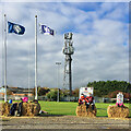
Rugby club, Anlaby Common
Hullensians https://hullensiansrufc.rfu.club/ Rugby Union club's ground on Springhead Lane. In common with many houses and other premises in the area, stuffed guys have appeared (here dressed in rugby kit). Whether these are meant as scary Halloween figures or the more traditional Guy Fawkes effigies, is not clear, though the two traditions seem to be becoming one extended event.
Image: © Paul Harrop
Taken: 20 Oct 2020
0.12 miles
9
A horse on Anlaby Common
This was one of many that came to greet the photographer.
Image: © Peter Church
Taken: 14 Feb 2008
0.13 miles
10
Springfield Way, Anlaby Common
The road links the Anlaby Common area with the Haltemprice roundabout at the edge of Kirk Ella. It is mainly lined with commercial and retail premises, but does have a few houses directly facing on to it at either end.
Image: © Paul Harrop
Taken: 18 Apr 2018
0.14 miles


