IMAGES TAKEN NEAR TO
Well Lane, HULL, HU10 6HE
Introduction
This page details the photographs taken nearby to Well Lane, HU10 6HE by members of the Geograph project.
The Geograph project started in 2005 with the aim of publishing, organising and preserving representative images for every square kilometre of Great Britain, Ireland and the Isle of Man.

There are currently over 7.5m images from over14,400 individuals and you can help contribute to the project by visiting https://www.geograph.org.uk
Image Map
Images are licensed for reuse under creativecommons.org/licenses/by-sa/2.0
Notes
- Clicking on the map will re-center to the selected point.
- The higher the marker number, the further away the image location is from the centre of the postcode.
Image Listing (15 Images Found)
Images are licensed for reuse under creativecommons.org/licenses/by-sa/2.0
Image
Details
Distance
2
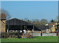
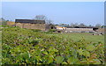
Farm at Willerby
Bellfield Farm, seen from the east on Well Lane. The dairy herd farmed here can just about be made out in the yard, being fed bales of fodder; presumably it is not yet time for them to be let out on to the fields.
Image: © Paul Harrop
Taken: 14 Mar 2022
0.07 miles
4

Self-service dairy shop, Willerby
Customers arrive at 'The Milk Well' at Bellfield Farm on Well Lane. Equipped with vending machines for the farm's milk, as well as for glass bottles and coffee, the shop opened in late October 2022. (For an inside view, see Image).
Founded in 1928, the original 'Botanic' pedigree herd took its name from the former Botanic railway station in Hull. Today the 200-acre farm on greenbelt land between Willerby and Cottingham has 70 Holstein and Jersey cows.
The farm joins an estimated 400 others around the UK which are turning to selling milk directly to consumers from vending machines in an attempt to counter the low wholesale prices paid to farmers.
Image: © Paul Harrop
Taken: 17 Dec 2022
0.09 miles
5
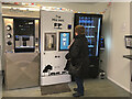
Inside The Milk Well, Willerby
Vending machines inside Image The touch-screen controls and contactless card payment technology seemed simple enough for even slightly confused elderly customers.
Image: © Paul Harrop
Taken: 17 Dec 2022
0.10 miles
6
Willerby Carr Lane Primary School.
This school which is soon to be demolished was built in 1937. It will be replaced by a new building which is adjacent to this one.
Image: © Steve Buttle
Taken: 14 May 2008
0.16 miles
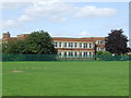
7
Wolfreton School, Willerby
Secondary school and sixth form college https://www.wolfreton.co.uk/ on Well Lane. The school originally operated over two sites which opened in the late 1950s/early 1960s. This new single-site school was opened in June 2017 on the former lower school campus (poor-quality image of how this looked 14 years previously, here: Image).
Image: © Paul Harrop
Taken: 6 Jul 2021
0.18 miles