IMAGES TAKEN NEAR TO
Ellerker Rise, HULL, HU10 6EY
Introduction
This page details the photographs taken nearby to Ellerker Rise, HU10 6EY by members of the Geograph project.
The Geograph project started in 2005 with the aim of publishing, organising and preserving representative images for every square kilometre of Great Britain, Ireland and the Isle of Man.

There are currently over 7.5m images from over14,400 individuals and you can help contribute to the project by visiting https://www.geograph.org.uk
Image Map
Images are licensed for reuse under creativecommons.org/licenses/by-sa/2.0
Notes
- Clicking on the map will re-center to the selected point.
- The higher the marker number, the further away the image location is from the centre of the postcode.
Image Listing (43 Images Found)
Images are licensed for reuse under creativecommons.org/licenses/by-sa/2.0
Image
Details
Distance
2

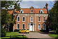
Willerby Hall
Probably originally late seventeenth century. http://www.britishlistedbuildings.co.uk/en-164690-willerby-hall-willerby-
Image: © Jonathan Thacker
Taken: 18 Nov 2014
0.14 miles
5

Close up, Elizabeth II postbox on Well Lane, Willerby
Postbox No. HU10 78.
See Image] for wider view.
Image: © JThomas
Taken: 9 Apr 2019
0.15 miles
6
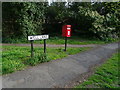
Elizabeth II postbox on Well Lane, Willerby
Image: © JThomas
Taken: 9 Apr 2019
0.15 miles

8
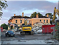
Demolition site, Willerby
Seen through the gate to the site from the footway on the public road outside, this structure on Well Lane is all that remains of the Willerby Manor Hotel. The hotel closed during the Covid 19 lockdown in 2020 and it was later announced that it would not re-open.
The original manor house dated from the late 19th century, was converted to a hotel around the start of the 1960s and later considerably extended. Geograph does not appear to have any pictures of it pre-demolition; the following link is to a history of the building and includes a number of maps and photographs:
https://u3asites.org.uk/files/a/awake/docs/willerbymanorpart2.pdf
The site has been sold and will be developed by Duchy Homes into an estate of 50 houses, under the banner of 'Manor Grange'.
Image: © Paul Harrop
Taken: 25 Jul 2022
0.16 miles
9
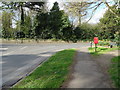
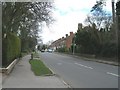
Well Lane, Willerby
Junction with Main Street (National cycle route 1).
Showing position of Postbox No. HU10 78.
See Image] for postbox.
Image: © JThomas
Taken: 9 Apr 2019
0.16 miles