IMAGES TAKEN NEAR TO
Haydon Close, HULL, HU10 6AB
Introduction
This page details the photographs taken nearby to Haydon Close, HU10 6AB by members of the Geograph project.
The Geograph project started in 2005 with the aim of publishing, organising and preserving representative images for every square kilometre of Great Britain, Ireland and the Isle of Man.

There are currently over 7.5m images from over14,400 individuals and you can help contribute to the project by visiting https://www.geograph.org.uk
Image Map
Images are licensed for reuse under creativecommons.org/licenses/by-sa/2.0
Notes
- Clicking on the map will re-center to the selected point.
- The higher the marker number, the further away the image location is from the centre of the postcode.
Image Listing (54 Images Found)
Images are licensed for reuse under creativecommons.org/licenses/by-sa/2.0
Image
Details
Distance
1
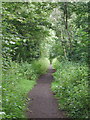
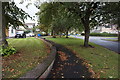
The Hull & Barnsley Railway
Remaining section of a railway embankment which runs from Gorton Road to Beverley Road in Kirk Ella, west of Hull and is now called the "Willerby and Kirk Ella Nature Trail". Self-seeded trees on either side of the six or seven metre high embankment were supplemented with the planting of hawthorn, laurel, dog rose and holly bushes from 1996 to 2001.
The Hull & Barnsley Railway was built in the 1880s together with the Alexandra Dock in Hull, to break the monopoly of the North Eastern Railway Company and provide an additional trading route inland from the busy Humber port. The railway didn't last long. Services west of South Howden station were withdrawn from 1st January 1932 and the regular service between Hull and South Howden ended on 30th July 1955, although some excursion traffic continued to use the line until about 1958. After that only a short section remained in Hull serving the local chemical works, although another stretch of the old line just south of Selby was reopened in the 1970s for delivering coal to the newly built Drax Power Station.
Image: © Paul Glazzard
Taken: 30 Jul 2007
0.04 miles
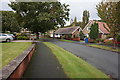
4
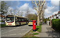
Kingston Road (B1232)
Showing position of Postbox No. HU10 30.
See Image] for postbox.
Image: © JThomas
Taken: 9 Apr 2019
0.08 miles
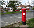
6
Kingston Road (B1232)
Showing position of Postbox No. HU10 30.
See Image] for postbox.
Image: © JThomas
Taken: 9 Apr 2019
0.09 miles
7
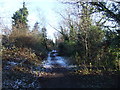
Footpath on the elevated stretch of old railway
Image: © David Brown
Taken: 23 Jan 2019
0.10 miles
9
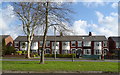
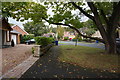
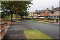
Houses on Kingston Road
Looking across the B1232.
Image: © JThomas
Taken: 9 Apr 2019
0.10 miles
10

Kingston Road (B1232)
Showing position of Postbox No. HU10 30.
See Image] for postbox.
Image: © JThomas
Taken: 9 Apr 2019
0.10 miles