IMAGES TAKEN NEAR TO
HS9 5YF
Introduction
This page details the photographs taken nearby to HS9 5YF by members of the Geograph project.
The Geograph project started in 2005 with the aim of publishing, organising and preserving representative images for every square kilometre of Great Britain, Ireland and the Isle of Man.

There are currently over 7.5m images from over14,400 individuals and you can help contribute to the project by visiting https://www.geograph.org.uk
Image Map (Loading...)


Getting Data...Please wait
Leaflet Map data © OpenStreetMap
Images are licensed for reuse under creativecommons.org/licenses/by-sa/2.0
Notes
- Clicking on the map will re-center to the selected point.
- The higher the marker number, the further away the image location is from the centre of the postcode.
Image Listing (38 Images Found)
Images are licensed for reuse under creativecommons.org/licenses/by-sa/2.0
Image
Details
Distance
1
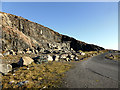
Quarry by the Vatersay Causeway
Seems highly likelely that stone for the causeway was extracted from here.
Image: © John Lucas
Taken: 9 Nov 2014
0.02 miles
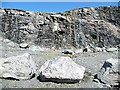
2
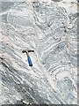
Shear Zone in Lewisian Gneiss
The quarry from which the stone for the Bhatarsaigh causeway was extracted has laid bare a large area of fresh rock surfaces. This part of the rock has undergone shearing while still ductile, distorting the bands of minerals making up the gneiss.
Image: © Anne Burgess
Taken: 26 May 2009
0.02 miles
3
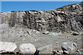
Quarry near Vatersay causeway
General shot of quarry.
Image: © Stephen Darlington
Taken: 26 May 2009
0.02 miles
4
The Vatersay causeway quarry
Quarry at the northern [Barra] end of the Vatersay causeway which was opened in 1990 and is made of thousands of tons of gneiss extracted from here.
Image: © Gordon Hatton
Taken: 23 Aug 2010
0.03 miles
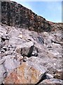
5
Bhatarsaigh Causeway Quarry
This is the hole left at the southern end of the Isle of Barra, where the stone for the causeway was quarried. It is mostly Lewisian gneiss, but there are some later igneous dykes cutting vertically through the gneiss just right of centre. The large boulders mark the quarry limits and deter some inappropriate uses of the quarry.
Image: © Anne Burgess
Taken: 26 May 2009
0.03 miles
6
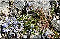
Milkwort (Polygala sp)
An unusually pale blue variety, growing prostrate in the rubble of the quarry by the Bhatarsaigh causeway.
Image: © Anne Burgess
Taken: 26 May 2009
0.03 miles
7
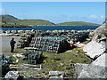
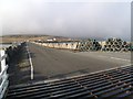
Lobster Creels
A large stack of creels by the Barra end of the causeway to Vatersay, part of which is visible in the background.
Image: © Anne Burgess
Taken: 26 May 2009
0.06 miles
8
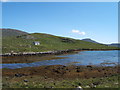
North-eastward from Vatersay to Barra
With Sheabhal in the background.
Image: © Barbara Carr
Taken: 8 Jun 2009
0.06 miles
10
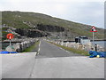
Causeway to Barra from Vatersay
With the quarry beyond which no doubt contributed to its construction; construction began in 1989 and was finished in 1991. It is 250m long and the final cost was £3.7million.
Image: © M J Richardson
Taken: 3 Aug 2015
0.08 miles