IMAGES TAKEN NEAR TO
Borve, ISLE OF BARRA, HS9 5XR
Introduction
This page details the photographs taken nearby to HS9 5XR by members of the Geograph project.
The Geograph project started in 2005 with the aim of publishing, organising and preserving representative images for every square kilometre of Great Britain, Ireland and the Isle of Man.

There are currently over 7.5m images from over14,400 individuals and you can help contribute to the project by visiting https://www.geograph.org.uk
Image Map (Loading...)


Getting Data...Please wait
Leaflet Map data © OpenStreetMap
Images are licensed for reuse under creativecommons.org/licenses/by-sa/2.0
Notes
- Clicking on the map will re-center to the selected point.
- The higher the marker number, the further away the image location is from the centre of the postcode.
Image Listing (11 Images Found)
Images are licensed for reuse under creativecommons.org/licenses/by-sa/2.0
Image
Details
Distance
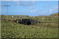
2
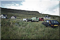
Hay cutting
Grass was being cut using a small tractor and organised using hand tools - it is low intensity practices like this that have allowed Corncrakes to survive in the Hebrides and Orkney having been virtually wiped out on the Mainland.
Image: © Hugh Venables
Taken: 19 Sep 2006
0.15 miles
6
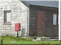
Borve: postbox № HS9 14
This postbox is unusually positioned in someone's garden - I suspect the reason is that the post office, which existed from 14 May 1886 until roughly 2001 - had the outbuilding alongside the box as its last premises.
Image: © Chris Downer
Taken: 12 Aug 2012
0.22 miles
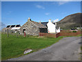
8
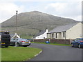
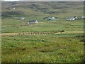
Houses at Borve/Borgh
With Beinn Mhartainn appearing to tower behind, even though it is only 244m a.s.l.
Image: © M J Richardson
Taken: 4 Aug 2015
0.23 miles
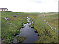
9
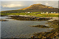
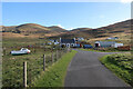
Beinn Mhartainn overlooking the township of Borgh
Image: © Mick Garratt
Taken: 14 Aug 2017
0.24 miles