IMAGES TAKEN NEAR TO
Horve, ISLE OF BARRA, HS9 5XE
Introduction
This page details the photographs taken nearby to HS9 5XE by members of the Geograph project.
The Geograph project started in 2005 with the aim of publishing, organising and preserving representative images for every square kilometre of Great Britain, Ireland and the Isle of Man.

There are currently over 7.5m images from over14,400 individuals and you can help contribute to the project by visiting https://www.geograph.org.uk
Image Map (Loading...)


Getting Data...Please wait
Leaflet Map data © OpenStreetMap
Images are licensed for reuse under creativecommons.org/licenses/by-sa/2.0
Notes
- Clicking on the map will re-center to the selected point.
- The higher the marker number, the further away the image location is from the centre of the postcode.
Image Listing (19 Images Found)
Images are licensed for reuse under creativecommons.org/licenses/by-sa/2.0
Image
Details
Distance
1
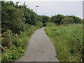
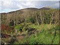
Footpath, Horve
Through some of the densest cover on the island, though there are some small areas of larger trees.
Image: © Hugh Venables
Taken: 1 Sep 2011
0.05 miles
2
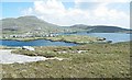
Castlebay from Nasg
There is a mast on the top of the hill above Nasg, and you have to stand close to it to avoid getting it in your view. The hill on the skyline is Heabhal, the highest point on the Isle of Barra.
Image: © Anne Burgess
Taken: 26 May 2009
0.06 miles
3
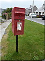
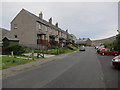
Castlebay: postbox № HS9 5, St. Brendan?s Road
A small postbox, one of two boxes in Castlebay, serving the western housing area of the village. It is emptied at 9:45 on weekday mornings and two hours earlier on Saturdays.
Image: © Chris Downer
Taken: 12 Aug 2012
0.07 miles
4
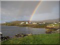
Double rainbow over Horve, Castlebay
The brightest of several rainbows in a period of sunshine and squalls. The large roof on the left is the hospital, at which there is a single doctor.
Image: © Hugh Venables
Taken: 4 Sep 2011
0.09 miles
5
Wooded area, Castlebay
One of a few areas of dense cover around the football pitch in Castlebay.
Image: © Hugh Venables
Taken: 19 Sep 2012
0.11 miles
9
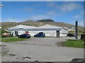
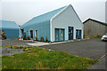
Co-operative store
The supermarket in Castlebay, with a view to the summit of Heabhal, in shadow, for effect! What an extraordinary setting.
Image: © Jonathan Wilkins
Taken: 11 May 2022
0.14 miles
10
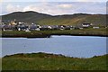
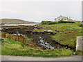
View across Bagh Beag towards Castlebay
Image: © David Martin
Taken: 29 Jul 2012
0.14 miles