IMAGES TAKEN NEAR TO
Ledaig, ISLE OF BARRA, HS9 5UL
Introduction
This page details the photographs taken nearby to HS9 5UL by members of the Geograph project.
The Geograph project started in 2005 with the aim of publishing, organising and preserving representative images for every square kilometre of Great Britain, Ireland and the Isle of Man.

There are currently over 7.5m images from over14,400 individuals and you can help contribute to the project by visiting https://www.geograph.org.uk
Image Map (Loading...)


Getting Data...Please wait
Leaflet Map data © OpenStreetMap
Images are licensed for reuse under creativecommons.org/licenses/by-sa/2.0
Notes
- Clicking on the map will re-center to the selected point.
- The higher the marker number, the further away the image location is from the centre of the postcode.
Image Listing (153 Images Found)
Images are licensed for reuse under creativecommons.org/licenses/by-sa/2.0
Image
Details
Distance
3
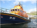
'RNLB Beth Sell' 17-33
A Severn-class lifeboat at its mooring in Castlebay/Bàgh a' Chaisteil, Barra. Currently listed as a relief boat. The Barra boat 'RNLB Edna Windsor' 17-12 was also in harbour Image
Image: © M J Richardson
Taken: 3 Aug 2015
0.15 miles
4
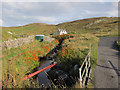
Allt a' Ghlinne
Just before reaching the sea in Castlebay.
Image: © Hugh Venables
Taken: 3 Sep 2011
0.15 miles
5
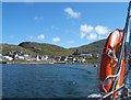
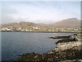
Castlebay
View towards the church at Castlebay from the ferry to Kisimul Castle.
Image: © Barbara Carr
Taken: 12 Jun 2009
0.15 miles
6
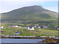
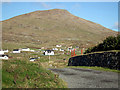
Sheabhal from Leadaig
View of Barra's highest mountain (380m / 1260 feet) from the shore at Bagh a Chaisteil.
www.isleofbarra.com
Image: © Colin Smith
Taken: 19 Jul 2011
0.16 miles
7
Rhue, Barra
Viewed from Pier Road, Castlebay.
Image: © John Lucas
Taken: 9 Nov 2014
0.16 miles
8
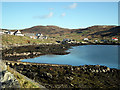
On the shore of Bagh a Chaisteil
The eastern shore of the sheltered bay on which stands the village of Castlebay.
Image: © Gordon Hatton
Taken: 25 Aug 2010
0.16 miles
9
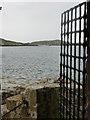
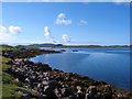
Castlebay: view through castle gate
Looking out of the gate of Image towards the eastern side of Castle Bay. The island in the background is named Orasaigh, not unusually for small Hebridean islands.
Image: © Chris Downer
Taken: 12 Aug 2012
0.16 miles
10
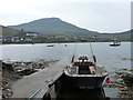
Castlebay: the castle ferry awaits its return journey
The little ferry to and from Image is moored against the castle jetty, waiting for one of its half-hourly runs back to Castlebay village. It returns to the jetty that is half in the picture on the left-hand edge.
The ferry does a circuit of the castle on the return trip, rather than going directly across.
Image: © Chris Downer
Taken: 12 Aug 2012
0.16 miles