IMAGES TAKEN NEAR TO
An Goirtean, ISLE OF BARRA, HS9 5UA
Introduction
This page details the photographs taken nearby to An Goirtean, HS9 5UA by members of the Geograph project.
The Geograph project started in 2005 with the aim of publishing, organising and preserving representative images for every square kilometre of Great Britain, Ireland and the Isle of Man.

There are currently over 7.5m images from over14,400 individuals and you can help contribute to the project by visiting https://www.geograph.org.uk
Image Map (Loading...)


Getting Data...Please wait
Leaflet Map data © OpenStreetMap
Images are licensed for reuse under creativecommons.org/licenses/by-sa/2.0
Notes
- Clicking on the map will re-center to the selected point.
- The higher the marker number, the further away the image location is from the centre of the postcode.
Image Listing (19 Images Found)
Images are licensed for reuse under creativecommons.org/licenses/by-sa/2.0
Image
Details
Distance
2
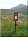
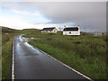
Breivig: postbox № HS9 10
This postbox is emptied at 8:45 on weekday mornings and at 6:45 on Saturday mornings. The large hill in the background is Sheabhal, the highest point of the island.
Image: © Chris Downer
Taken: 12 Aug 2012
0.03 miles
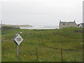
4
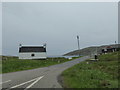
The A888 at the head of B?gh Bhreibhig
Heabhal rising on the skyline.
Image: © John Allan
Taken: 28 Sep 2020
0.05 miles
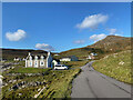
5
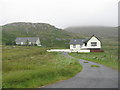
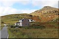
House at An Goirtean
Looking out to Bàgh Bhreibhig.
Image: © M J Richardson
Taken: 4 Aug 2015
0.05 miles
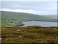
8
Barra from top to toe
The east coast road at sea level and the highest point, Heabhal
Image: © Alan Reid
Taken: 1 Oct 2019
0.15 miles