IMAGES TAKEN NEAR TO
Slighe Ruairidh Chalum Ruairidh, ISLE OF SOUTH UIST, HS8 5SZ
Introduction
This page details the photographs taken nearby to Slighe Ruairidh Chalum Ruairidh, HS8 5SZ by members of the Geograph project.
The Geograph project started in 2005 with the aim of publishing, organising and preserving representative images for every square kilometre of Great Britain, Ireland and the Isle of Man.

There are currently over 7.5m images from over14,400 individuals and you can help contribute to the project by visiting https://www.geograph.org.uk
Image Map
Images are licensed for reuse under creativecommons.org/licenses/by-sa/2.0
Notes
- Clicking on the map will re-center to the selected point.
- The higher the marker number, the further away the image location is from the centre of the postcode.
Image Listing (9 Images Found)
Images are licensed for reuse under creativecommons.org/licenses/by-sa/2.0
Image
Details
Distance
1
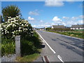
Looking North up the B888
From the Burnside Filling Station and Chip-shop, towards Dalibrog School.
Image: © Barbara Carr
Taken: 11 Jun 2009
0.02 miles
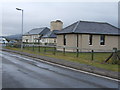
2
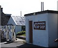
Burnside Filling Station and Chip-shop
Just south of Dalibrog School on the B888.
Image: © Barbara Carr
Taken: 11 Jun 2009
0.08 miles
3
Burnside petrol station
Also a fish and chip shop.
Image: © Hugh Venables
Taken: 20 Sep 2012
0.08 miles
4
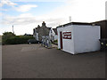
The B888 south from Burnside
Looking south from Burnside Filling Station and Chip-shop.
Image: © Barbara Carr
Taken: 11 Jun 2009
0.09 miles
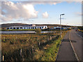
5
Sgoil Dhalabroig
Dalabrog School on the B888.
Image: © Barbara Carr
Taken: 13 Jun 2009
0.11 miles

8
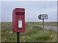
Strome: postbox № HS8 51
This postbox stands at the junction of the B888 with the lane down to Strome. It is emptied at noon on weekdays and at 7:15 on Saturday mornings.
Image: © Chris Downer
Taken: 13 Aug 2012
0.23 miles
9
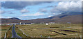
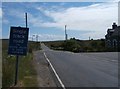
Daliburgh School from the south, on B888
Beinn Mhor, highest hill in South Uist, in background. The school is one of the largest buildings in this small village.
Image: © Greg Morss
Taken: 4 Oct 2006
0.23 miles