IMAGES TAKEN NEAR TO
Uskavagh, ISLE OF BENBECULA, HS7 5QL
Introduction
This page details the photographs taken nearby to HS7 5QL by members of the Geograph project.
The Geograph project started in 2005 with the aim of publishing, organising and preserving representative images for every square kilometre of Great Britain, Ireland and the Isle of Man.

There are currently over 7.5m images from over14,400 individuals and you can help contribute to the project by visiting https://www.geograph.org.uk
Image Map
Images are licensed for reuse under creativecommons.org/licenses/by-sa/2.0
Notes
- Clicking on the map will re-center to the selected point.
- The higher the marker number, the further away the image location is from the centre of the postcode.
Image Listing (4 Images Found)
Images are licensed for reuse under creativecommons.org/licenses/by-sa/2.0
Image
Details
Distance
1
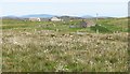
Crofts on the east side of Benbecula
This is almost at the end of the little road that winds its way across moors and by both sea and freshwater lochs to eventually reach Uisgeabhagh. A newer croft house to the left contrasts with an old single storey house to the right, no longer lived in and most likely doomed to slow decay.
Image: © Gordon Hatton
Taken: 23 Jun 2019
0.03 miles
2
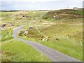
Minor road near Creagastrom
Minor road as it passes Buaile Rairnis
Image: © Stuart Wilding
Taken: 17 Jun 2008
0.23 miles
3
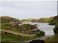
Loch Meanarbhagh
A small sea loch by Buaile Rairnis
Image: © Stuart Wilding
Taken: 17 Jun 2008
0.25 miles
4
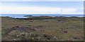
An unexciting patch of boggy moorland
There may be some interesting coastal scenery on the east side of this grid square, but the trek across a squelchy moor is just too much. The coast is visible here, as are one or two offshire islets. The moor appears to have been worked for peat in the past, and is full of wet patches.
Image: © Gordon Hatton
Taken: 26 Jul 2012
0.25 miles