IMAGES TAKEN NEAR TO
Griminish, ISLE OF NORTH UIST, HS6 5BZ
Introduction
This page details the photographs taken nearby to HS6 5BZ by members of the Geograph project.
The Geograph project started in 2005 with the aim of publishing, organising and preserving representative images for every square kilometre of Great Britain, Ireland and the Isle of Man.

There are currently over 7.5m images from over14,400 individuals and you can help contribute to the project by visiting https://www.geograph.org.uk
Image Map
Images are licensed for reuse under creativecommons.org/licenses/by-sa/2.0
Notes
- Clicking on the map will re-center to the selected point.
- The higher the marker number, the further away the image location is from the centre of the postcode.
Image Listing (4 Images Found)
Images are licensed for reuse under creativecommons.org/licenses/by-sa/2.0
Image
Details
Distance
1
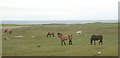
Grazing land at Griminis, North Uist
View looking north west of grazing land to the east of Loch an Eilean. The grazers here are horses and ponies of a riding centre.
Image: © eswales
Taken: 17 May 2006
0.12 miles
2
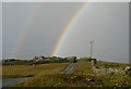
Approaching Callernish on a showery day
The grounds have been protected from the wind to give this unique house, polo-mint shaped in plan, a chance to have a wide variety of shrubs in its garden.
Image: © Alan Reid
Taken: 16 Oct 2011
0.16 miles
3
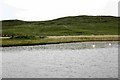
Dun in Loch an Eilean
Picture taken from East side of the Loch
Image: © Paul Store
Taken: 17 Jun 2005
0.21 miles
4
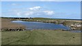
Loch an Eilean
A very reedy loch on the north coast of North Uist.
Image: © Richard Webb
Taken: 13 Apr 2012
0.24 miles