IMAGES TAKEN NEAR TO
Strond, ISLE OF HARRIS, HS5 3UD
Introduction
This page details the photographs taken nearby to HS5 3UD by members of the Geograph project.
The Geograph project started in 2005 with the aim of publishing, organising and preserving representative images for every square kilometre of Great Britain, Ireland and the Isle of Man.

There are currently over 7.5m images from over14,400 individuals and you can help contribute to the project by visiting https://www.geograph.org.uk
Image Map
Images are licensed for reuse under creativecommons.org/licenses/by-sa/2.0
Notes
- Clicking on the map will re-center to the selected point.
- The higher the marker number, the further away the image location is from the centre of the postcode.
Image Listing (11 Images Found)
Images are licensed for reuse under creativecommons.org/licenses/by-sa/2.0
Image
Details
Distance
1
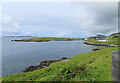
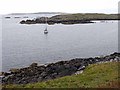
Cairminis (Carminish)
Bagh Cairminis (Carminish Bay) is well sheltered by Eilean nan Bridianach, which is actually a peninsula rather than an island.
Image: © Anne Burgess
Taken: 5 Aug 2023
0.03 miles
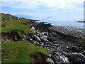
2
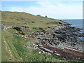
The rocky shore of B?gh Ch?irminis
On the walk from Leverburgh to Rodel.
Image: © Russel Wills
Taken: 9 May 2002
0.08 miles
3
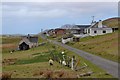
Cairminis grazers
Sheep and Greylag geese share a tasty patch of grass overlooking the Uists
Image: © Alan Reid
Taken: 6 Nov 2010
0.09 miles
5
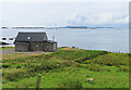
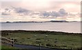
Wooden House at Srannda
Wooden houses are unusual in the Hebrides, but this one looks quite in harmony with its surroundings. In the distance is a glimpse of North Uist.
Image: © Anne Burgess
Taken: 5 Aug 2023
0.16 miles
8
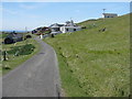
Road at Strond/Srannda
Coastal road south of Leverburgh.
Image: © M J Richardson
Taken: 1 Jun 2016
0.21 miles
9
Eilean nam Bridianach
It is not easy to make out the island as distinct from a peninsula of the mainland of the Isle of Harris immediately beyond. The island of Killegray Image can be seen in the distance.
Image: © Oliver Dixon
Taken: 12 Sep 2009
0.22 miles
10
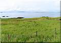
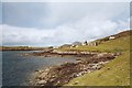
Srannda (Strond)
Looking down over small rough fields to the sea, with a distant glimpse of Berneray and North Uist beyond.
Image: © Anne Burgess
Taken: 5 Aug 2023
0.23 miles