IMAGES TAKEN NEAR TO
Laggandoin, ISLE OF SCALPAY, HS4 3YF
Introduction
This page details the photographs taken nearby to HS4 3YF by members of the Geograph project.
The Geograph project started in 2005 with the aim of publishing, organising and preserving representative images for every square kilometre of Great Britain, Ireland and the Isle of Man.

There are currently over 7.5m images from over14,400 individuals and you can help contribute to the project by visiting https://www.geograph.org.uk
Image Map
Images are licensed for reuse under creativecommons.org/licenses/by-sa/2.0
Notes
- Clicking on the map will re-center to the selected point.
- The higher the marker number, the further away the image location is from the centre of the postcode.
Image Listing (8 Images Found)
Images are licensed for reuse under creativecommons.org/licenses/by-sa/2.0
Image
Details
Distance
2
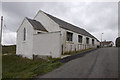
Scalpay Church of Scotland
The majority on Scalpay chose to remain in the Free Church when the United Free Church reunited with the established Church of Scotland in 1929. As the congregation was not enough to justify maintaining a large building and a resident minister, the Church of Scotland kept this small church where services were conducted by a lay missionary, who lived with his family in the nearby Image
Shortly after this photograph was taken the bridge linking Scalpay to the mainland of Harris was completed, making it possible for the remaining Church of Scotland congregation to attend Sunday services in Tarbert and so there was no longer any need for a missionary.
This small church is now used for services by the Free Church (Continuing). For a later view from the other side see Image
Image: © Tiger
Taken: 25 Aug 1997
0.08 miles
4
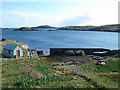
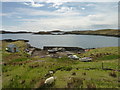
Small harbour on Scalpay
A concrete arm and narrow entrance mark this small harbour, south of the main settlement.
Image: © Bob Jones
Taken: 21 May 2006
0.08 miles
5

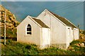
Scalpay Mission House
The corrugated building was once the home of the lay missionary who served the Image Following the opening of the Scalpay Bridge in 1997, soon after this photograph was taken, the small Church of Scotland congregation was able to travel to worship on the Harris mainland and missionaries no longer resided on the island.
Image: © Tiger
Taken: 25 Aug 1997
0.10 miles
7
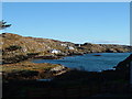
South Harbour at Scalpay
Although this grid square includes the village centre (shop, post office, school and playground), this is the view south east along the island showing the rocky shore
Image: © David Wake
Taken: 23 Oct 2005
0.13 miles