IMAGES TAKEN NEAR TO
Seilebost, ISLE OF HARRIS, HS3 3HN
Introduction
This page details the photographs taken nearby to HS3 3HN by members of the Geograph project.
The Geograph project started in 2005 with the aim of publishing, organising and preserving representative images for every square kilometre of Great Britain, Ireland and the Isle of Man.

There are currently over 7.5m images from over14,400 individuals and you can help contribute to the project by visiting https://www.geograph.org.uk
Image Map
Images are licensed for reuse under creativecommons.org/licenses/by-sa/2.0
Notes
- Clicking on the map will re-center to the selected point.
- The higher the marker number, the further away the image location is from the centre of the postcode.
Image Listing (18 Images Found)
Images are licensed for reuse under creativecommons.org/licenses/by-sa/2.0
Image
Details
Distance
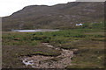
1
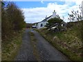
Laxdale Cottage
Part of the Borve Lodge Estate.
Image: © Gordon Brown
Taken: 25 May 2015
0.00 miles
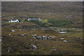
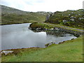
5
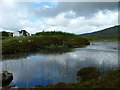
Loch Lacasdail
To the left is Laxdale (Lacasdail) Cottage
Image: © Dave Fergusson
Taken: 30 Jun 2011
0.05 miles
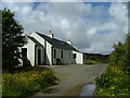
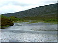
6
Laxdale Cottage and Loch of Lacasdail
Both spellings of the name.
Image: © Mike Pennington
Taken: 28 Jul 2011
0.06 miles

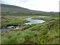
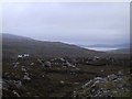
10
The old Rodel to Tarbert road skirts Loch Lacasdail
Image: © Dave Fergusson
Taken: 30 Jun 2011
0.14 miles