IMAGES TAKEN NEAR TO
Caw, ISLE OF HARRIS, HS3 3DN
Introduction
This page details the photographs taken nearby to HS3 3DN by members of the Geograph project.
The Geograph project started in 2005 with the aim of publishing, organising and preserving representative images for every square kilometre of Great Britain, Ireland and the Isle of Man.

There are currently over 7.5m images from over14,400 individuals and you can help contribute to the project by visiting https://www.geograph.org.uk
Image Map (Loading...)


Getting Data...Please wait
Leaflet Map data © OpenStreetMap
Images are licensed for reuse under creativecommons.org/licenses/by-sa/2.0
Notes
- Clicking on the map will re-center to the selected point.
- The higher the marker number, the further away the image location is from the centre of the postcode.
Image Listing (116 Images Found)
Images are licensed for reuse under creativecommons.org/licenses/by-sa/2.0
Image
Details
Distance
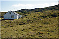
1
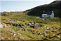
House at Direcleit
This is the area where homeless and landless families moved after being cleared from nearby Ceann Dibig, close to Tarbert where they may have been able to pick up some work. The bush in the distance is on the site of a ruined house.
Image: © Mike Pennington
Taken: 26 Jul 2011
0.01 miles
2
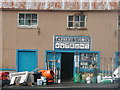
Tarbert Stores, Isle of Harris
Everything for the crofter, fisherman, householder and camper!
Image: © Sue Jackson
Taken: 10 Aug 2003
0.04 miles
3
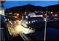
A dawn departure from Tarbert pier
Lights are still on at the ferry terminal while the sky lightens.
Image: © Alan Reid
Taken: 2 Oct 2009
0.04 miles
7
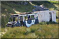
Wrecked bus at Direcleit
Although it looks pretty ancient, the First Bus logo and mobile number on the door show that it hasn't been here very long.
Image: © Mike Pennington
Taken: 26 Jul 2011
0.10 miles
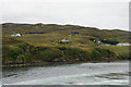
8
House at Direcleit and a view over Tarbert
Image: © Mike Pennington
Taken: 26 Jul 2011
0.12 miles
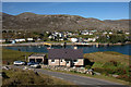
10
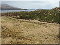
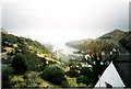
Woodland at Craobhag
With An Loch an Ear and Rubha na Muice beyond.
Image: © M J Richardson
Taken: 15 May 2013
0.16 miles