IMAGES TAKEN NEAR TO
Tarbert, ISLE OF HARRIS, HS3 3BL
Introduction
This page details the photographs taken nearby to HS3 3BL by members of the Geograph project.
The Geograph project started in 2005 with the aim of publishing, organising and preserving representative images for every square kilometre of Great Britain, Ireland and the Isle of Man.

There are currently over 7.5m images from over14,400 individuals and you can help contribute to the project by visiting https://www.geograph.org.uk
Image Map (Loading...)


Getting Data...Please wait
Leaflet Map data © OpenStreetMap
Images are licensed for reuse under creativecommons.org/licenses/by-sa/2.0
Notes
- Clicking on the map will re-center to the selected point.
- The higher the marker number, the further away the image location is from the centre of the postcode.
Image Listing (8 Images Found)
Images are licensed for reuse under creativecommons.org/licenses/by-sa/2.0
Image
Details
Distance
1
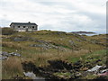
House at Cnoc na Greine
Overlooking An Loch an Ear.
Image: © M J Richardson
Taken: 15 May 2013
0.12 miles
2
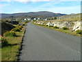
Houses at Cnoc na Greine
On the eastern outskirts of Tarbert/An Tairbeart, on the way to Scalpay.
Image: © M J Richardson
Taken: 15 May 2013
0.14 miles
3
The ferry from Uig slips past Rubha Dubh
The final approach to Tarbert.
Image: © Alan Reid
Taken: 28 Mar 1975
0.14 miles
4
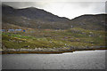
Looking Towards Tarbert
On the Scalpay to Tarbert road.
Image: © Dave Fergusson
Taken: 29 Sep 2007
0.15 miles
5
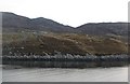
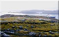
Rubha Dubh
A heathery headland on the north shore of East Loch Tarbert.
Image: © Richard Webb
Taken: 13 Apr 2009
0.18 miles
6
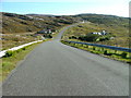
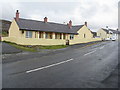
Houses at Oban
A small settlement on the Tarbert to Scalpay road.
Image: © Dave Fergusson
Taken: 29 Sep 2007
0.23 miles
7
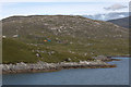
Rubha Dubh, Tarbert (An Tairbeart)
Headland just beside the settlement at Tarbert.
Image: © Mike Pennington
Taken: 25 Jul 2011
0.23 miles