IMAGES TAKEN NEAR TO
Lon Ban, ISLE OF LEWIS, HS2 9RF
Introduction
This page details the photographs taken nearby to Lon Ban, HS2 9RF by members of the Geograph project.
The Geograph project started in 2005 with the aim of publishing, organising and preserving representative images for every square kilometre of Great Britain, Ireland and the Isle of Man.

There are currently over 7.5m images from over14,400 individuals and you can help contribute to the project by visiting https://www.geograph.org.uk
Image Map (Loading...)


Getting Data...Please wait
Leaflet Map data © OpenStreetMap
Images are licensed for reuse under creativecommons.org/licenses/by-sa/2.0
Notes
- Clicking on the map will re-center to the selected point.
- The higher the marker number, the further away the image location is from the centre of the postcode.
Image Listing (3 Images Found)
Images are licensed for reuse under creativecommons.org/licenses/by-sa/2.0
Image
Details
Distance
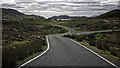
1
B8060 to Leumrebhagh
The Shiant Isles are visible in the distance.
Image: © Steven Brown
Taken: 7 Jun 2007
0.06 miles
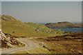
2

Near Leumrabhagh
Looking towards the village of Leumrabhagh from a vantage point to the north of the village.
Image: © Eileen Henderson
Taken: 29 Jun 2007
0.22 miles