IMAGES TAKEN NEAR TO
Glen, Gravir, ISLE OF LEWIS, HS2 9QY
Introduction
This page details the photographs taken nearby to HS2 9QY by members of the Geograph project.
The Geograph project started in 2005 with the aim of publishing, organising and preserving representative images for every square kilometre of Great Britain, Ireland and the Isle of Man.

There are currently over 7.5m images from over14,400 individuals and you can help contribute to the project by visiting https://www.geograph.org.uk
Image Map (Loading...)


Getting Data...Please wait
Leaflet Map data © OpenStreetMap
Images are licensed for reuse under creativecommons.org/licenses/by-sa/2.0
Notes
- Clicking on the map will re-center to the selected point.
- The higher the marker number, the further away the image location is from the centre of the postcode.
Image Listing (3 Images Found)
Images are licensed for reuse under creativecommons.org/licenses/by-sa/2.0
Image
Details
Distance
2
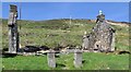
Ruined house, Glenside/Taobh a' Ghlinne, Isle of Lewis
Looking at old OS maps suggests that the house was built in the 1950s.
Image: © Claire Pegrum
Taken: 25 May 2018
0.08 miles
3
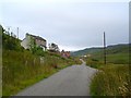
Houses in Glenside
Looking East down Glen Grabhair along the single track village road.
Image: © Donald Lawson
Taken: 5 Aug 2006
0.09 miles