IMAGES TAKEN NEAR TO
East End, ISLE OF LEWIS, HS2 9PW
Introduction
This page details the photographs taken nearby to East End, HS2 9PW by members of the Geograph project.
The Geograph project started in 2005 with the aim of publishing, organising and preserving representative images for every square kilometre of Great Britain, Ireland and the Isle of Man.

There are currently over 7.5m images from over14,400 individuals and you can help contribute to the project by visiting https://www.geograph.org.uk
Image Map
Images are licensed for reuse under creativecommons.org/licenses/by-sa/2.0
Notes
- Clicking on the map will re-center to the selected point.
- The higher the marker number, the further away the image location is from the centre of the postcode.
Image Listing (9 Images Found)
Images are licensed for reuse under creativecommons.org/licenses/by-sa/2.0
Image
Details
Distance
1
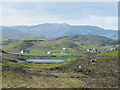
Baile Ailein (Balallan)
A foreshortened view of Baile Ailein from the top of Cnoc a' Ghille Ruaidh Bhig seems to crowd the village at the foot of the hills. I can't quite make up my mind whether the most prominent hill is Dùn Chonaill in Image or Cadha Cleit in Image, but it's probably the latter.
Image: © Anne Burgess
Taken: 19 May 2011
0.08 miles
2

Baile Ailean (Balallan)
The outlying part of the village of Baile Ailean, with Dire Bhail'Ailein behind it and Loch na Deasport in front.
Image: © Anne Burgess
Taken: 19 May 2011
0.10 miles
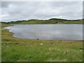
5
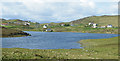
Baile Ailean (Balallan) and Loch na Deasport
The loch marks the eastern extremity of the crofting township of Baile Ailean. On older maps it is named Loch nan Deaspoirt. In the background are some of the hills north of Loch Shiphoirt (Loch Seaforth).
Image: © Anne Burgess
Taken: 19 May 2011
0.15 miles
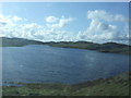
6
Loch nan Deas Phoirt
At the east end of the community of Baile Ailean.
Image: © John Allan
Taken: 18 Jul 2006
0.16 miles
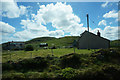
7
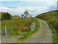
Tearoom and Gallery in Baile Ailein
Just off the main Stornoway road.
Image: © Dave Fergusson
Taken: 12 Aug 2008
0.20 miles
8
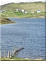
Loch na Deasport
Or, if you prefer the spelling on the older maps, Loch nan Deaspoirt. The houses are the easternmost in Baile Ailean (Balallan).
Image: © Anne Burgess
Taken: 19 May 2011
0.22 miles
9
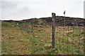
Fence line at Balallan
I was going to walk further in but the weather was so miserable, typically Lewis, that the fence was as far as I got before the rain was on my lens!
Image: © Stephen Branley
Taken: 6 May 2009
0.23 miles