IMAGES TAKEN NEAR TO
Lochs Road, ISLE OF LEWIS, HS2 9NF
Introduction
This page details the photographs taken nearby to Lochs Road, HS2 9NF by members of the Geograph project.
The Geograph project started in 2005 with the aim of publishing, organising and preserving representative images for every square kilometre of Great Britain, Ireland and the Isle of Man.

There are currently over 7.5m images from over14,400 individuals and you can help contribute to the project by visiting https://www.geograph.org.uk
Image Map
Images are licensed for reuse under creativecommons.org/licenses/by-sa/2.0
Notes
- Clicking on the map will re-center to the selected point.
- The higher the marker number, the further away the image location is from the centre of the postcode.
Image Listing (4 Images Found)
Images are licensed for reuse under creativecommons.org/licenses/by-sa/2.0
Image
Details
Distance
1
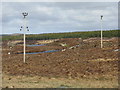
Power lines by Loch Leiniscal
Given the windy nature of the climate, the double stay of many of the transmission poles in the islands is a provident feature. A relatively large conifer plantation is in the background.
Image: © M J Richardson
Taken: 15 May 2013
0.11 miles
2
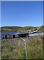
Fish farm, Loch Leiniscal, Isle of Lewis
This loch is listed on the Scotland's Aquaculture website as being used for the production of rainbow trout.
Image: © Claire Pegrum
Taken: 3 Jun 2018
0.11 miles
3
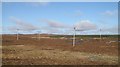
Moorland by Loch Leiniscal
Bogland beside the main road south of Stornoway with powerlines coming up from Harris and a small block of forestry beyond Loch Leiniscal.
Image: © Richard Webb
Taken: 8 Apr 2009
0.14 miles
4
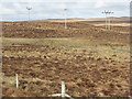
Moorland on the Isle of Lewis
Electricity transmission lines alongside the A859 Stornoway-Tarbert Road. Masts on Èitseal in Image are just visible on the horizon 6.5km away.
Image: © M J Richardson
Taken: 15 May 2013
0.19 miles