IMAGES TAKEN NEAR TO
Dun Innes, ISLE OF LEWIS, HS2 9LY
Introduction
This page details the photographs taken nearby to Dun Innes, HS2 9LY by members of the Geograph project.
The Geograph project started in 2005 with the aim of publishing, organising and preserving representative images for every square kilometre of Great Britain, Ireland and the Isle of Man.

There are currently over 7.5m images from over14,400 individuals and you can help contribute to the project by visiting https://www.geograph.org.uk
Image Map
Images are licensed for reuse under creativecommons.org/licenses/by-sa/2.0
Notes
- Clicking on the map will re-center to the selected point.
- The higher the marker number, the further away the image location is from the centre of the postcode.
Image Listing (3 Images Found)
Images are licensed for reuse under creativecommons.org/licenses/by-sa/2.0
Image
Details
Distance
3
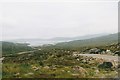
Looking down at Circebost
Circebost or Kirkibost is a tiny settlement on Great Bernera. This island is now connected to Lewis by a short pre-stressed concrete bridge. In 1953 when it was built it was and remains the first bridge of such material in Europe.
The settlemenr is also important as it is the first planned crofting township in the Outer Hebrides, though I think town is a lofty description for such a small group of houses.
Image: © Malcolm Neal
Taken: 16 Jul 2002
0.24 miles