IMAGES TAKEN NEAR TO
Keose Glebe, ISLE OF LEWIS, HS2 9JX
Introduction
This page details the photographs taken nearby to HS2 9JX by members of the Geograph project.
The Geograph project started in 2005 with the aim of publishing, organising and preserving representative images for every square kilometre of Great Britain, Ireland and the Isle of Man.

There are currently over 7.5m images from over14,400 individuals and you can help contribute to the project by visiting https://www.geograph.org.uk
Image Map
Images are licensed for reuse under creativecommons.org/licenses/by-sa/2.0
Notes
- Clicking on the map will re-center to the selected point.
- The higher the marker number, the further away the image location is from the centre of the postcode.
Image Listing (4 Images Found)
Images are licensed for reuse under creativecommons.org/licenses/by-sa/2.0
Image
Details
Distance
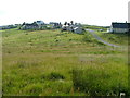
2
Evening over Glib Cheois
Evening view over Glib Cheois
Image: © Graham Maxwell
Taken: 4 Jul 2005
0.06 miles
3
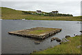
Platform in Loch Cheois
This small concrete platform is at the southern end of Loch Cheois. There is nothing to indicate its function. (There is a slight possibility that it is associated with the WWII "chariot" training facility at Tavay.)
Image: © Rob Burke
Taken: 28 Aug 2011
0.19 miles
4
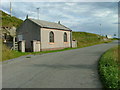
Free Church of Scotland Meeting house
In the township of Ceos.
Image: © Dave Fergusson
Taken: 12 Aug 2008
0.23 miles