IMAGES TAKEN NEAR TO
Geshader, ISLE OF LEWIS, HS2 9HL
Introduction
This page details the photographs taken nearby to HS2 9HL by members of the Geograph project.
The Geograph project started in 2005 with the aim of publishing, organising and preserving representative images for every square kilometre of Great Britain, Ireland and the Isle of Man.

There are currently over 7.5m images from over14,400 individuals and you can help contribute to the project by visiting https://www.geograph.org.uk
Image Map (Loading...)


Getting Data...Please wait
Leaflet Map data © OpenStreetMap
Images are licensed for reuse under creativecommons.org/licenses/by-sa/2.0
Notes
- Clicking on the map will re-center to the selected point.
- The higher the marker number, the further away the image location is from the centre of the postcode.
Image Listing (5 Images Found)
Images are licensed for reuse under creativecommons.org/licenses/by-sa/2.0
Image
Details
Distance
1
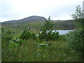
Geisiadar woods
Native woods in Geisiadar on An t-Seoc's croft
Image: © Gus Macdonald
Taken: 23 Jul 2008
0.11 miles
2
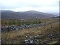
Great wall of Geisiadar
The rear boundary to Croft Number 8 at Geisiadr. The houses at Numbers 7 and 8 are in the pic. The wall was of course built to protect the township of Geisidar from the maurauding hordes known as the Ungesiadar folk.
Image: © Gus Macdonald
Taken: 24 Dec 2008
0.20 miles
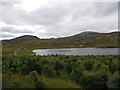
3
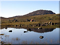
Loch Geshader
Looking towards crofts 3 and 4; the hill is Seabhal
Image: © Sarah Egan
Taken: 30 Sep 2007
0.22 miles
4
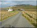
Croft at Geisiadar
Sgrithir is the hill beyond. The loch to the left is Loch Geisiadar.
Image: © Dave Fergusson
Taken: 1 Oct 2007
0.22 miles
5
Geisiadar
On Croft Number 8 - The Crofting Commission are looking to evict the tenant of this croft and destroy the woods.
Image: © Gus Macdonald
Taken: 8 Aug 2012
0.24 miles