IMAGES TAKEN NEAR TO
Gisla, ISLE OF LEWIS, HS2 9EW
Introduction
This page details the photographs taken nearby to HS2 9EW by members of the Geograph project.
The Geograph project started in 2005 with the aim of publishing, organising and preserving representative images for every square kilometre of Great Britain, Ireland and the Isle of Man.

There are currently over 7.5m images from over14,400 individuals and you can help contribute to the project by visiting https://www.geograph.org.uk
Image Map
Images are licensed for reuse under creativecommons.org/licenses/by-sa/2.0
Notes
- Clicking on the map will re-center to the selected point.
- The higher the marker number, the further away the image location is from the centre of the postcode.
Image Listing (7 Images Found)
Images are licensed for reuse under creativecommons.org/licenses/by-sa/2.0
Image
Details
Distance
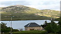
1
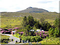
Gisla
Gisla seen from across Little Loch Roag
Image: © Sarah Egan
Taken: 30 Sep 2007
0.03 miles
2
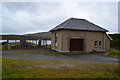
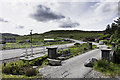
Gisla Power Station
A small hydroelectric power station, using water piped from Loch Coirceabhat.
Image: © David Martin
Taken: 2 Aug 2012
0.04 miles
3
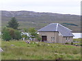
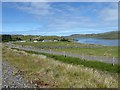
Gisla Power Station
Small HEP station on the western shore of Loch Rog Beag at Giosla.
Image: © Colin Smith
Taken: 29 Jul 2011
0.04 miles
4
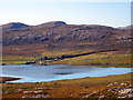
Power Station at Giosla.
This appears to be a small hydro-electric plant using water from Loch More Coirgavat, which is half a mile away and 50 metres higher up the hillside.
Image: © Gordon Hatton
Taken: 15 Jul 2007
0.07 miles