IMAGES TAKEN NEAR TO
Carishader, ISLE OF LEWIS, HS2 9ER
Introduction
This page details the photographs taken nearby to HS2 9ER by members of the Geograph project.
The Geograph project started in 2005 with the aim of publishing, organising and preserving representative images for every square kilometre of Great Britain, Ireland and the Isle of Man.

There are currently over 7.5m images from over14,400 individuals and you can help contribute to the project by visiting https://www.geograph.org.uk
Image Map
Images are licensed for reuse under creativecommons.org/licenses/by-sa/2.0
Notes
- Clicking on the map will re-center to the selected point.
- The higher the marker number, the further away the image location is from the centre of the postcode.
Image Listing (7 Images Found)
Images are licensed for reuse under creativecommons.org/licenses/by-sa/2.0
Image
Details
Distance
1
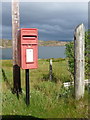
Cerishader: postbox № HS2 158
A small postbox on the B8011, with its back to Loch Ròg. It is emptied at 9 o'clock each morning, except Sunday.
Image: © Chris Downer
Taken: 18 Aug 2012
0.01 miles
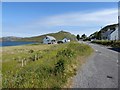
2
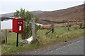
Carishader postbox
The sea inlet is part of Loch Ròg.
Image: © Alan Reid
Taken: 6 May 2018
0.02 miles
3
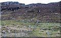
Cairisiadar: croft boundaries and common grazings
Image: © Alan Reid
Taken: 6 May 2018
0.06 miles
4
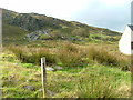
Rock Outcrop at Cairisiadar
On the eastern slopes of Sidhean a Deas.
Image: © Dave Fergusson
Taken: 1 Oct 2007
0.08 miles
6
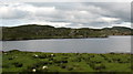
Looking across to Flodaigh
Flodaigh is a small island in Loch Rog, separated from mainland Lewis by the narrowest of channels at its southernmost point. There seem to be a number of Flodaigh [Flodday] islands around the west coast of Scotland, so presumably the name has some significance.
Image: © Gordon Hatton
Taken: 15 Jul 2007
0.21 miles
7
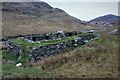
Old black house walls, Cairisiadar
Looking up An Gleann Ruadh.
Image: © Alan Reid
Taken: 6 May 2018
0.23 miles