IMAGES TAKEN NEAR TO
Ceanna'Tuath, ISLE OF LEWIS, HS2 9DJ
Introduction
This page details the photographs taken nearby to Ceanna'Tuath, HS2 9DJ by members of the Geograph project.
The Geograph project started in 2005 with the aim of publishing, organising and preserving representative images for every square kilometre of Great Britain, Ireland and the Isle of Man.

There are currently over 7.5m images from over14,400 individuals and you can help contribute to the project by visiting https://www.geograph.org.uk
Image Map
Images are licensed for reuse under creativecommons.org/licenses/by-sa/2.0
Notes
- Clicking on the map will re-center to the selected point.
- The higher the marker number, the further away the image location is from the centre of the postcode.
Image Listing (7 Images Found)
Images are licensed for reuse under creativecommons.org/licenses/by-sa/2.0
Image
Details
Distance
1
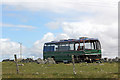
Abandoned coach Arnol
Presumably due to the cost of disposal, I've noticed a lot of abandoned vehicles on the islands around the UK.
Image: © Jo and Steve Turner
Taken: 13 Jun 2012
0.05 miles
2
Derelict house at Arnol
One of many all over the Outer Hebrides.
Image: © M J Richardson
Taken: 27 May 2016
0.06 miles
3
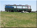
Bus at Arnol
Waiting for its final journey to the bus station in the sky! It has been there at least 4 years - see Image
Image: © M J Richardson
Taken: 27 May 2016
0.06 miles
4
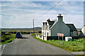
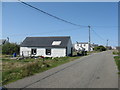
Local Road at Arnol
Arnol (Scottish Gaelic: Àrnol) is a small settlement on the west coast of the Isle of Lewis. Once a thriving township with over forty crofts, it now has a much lower number of active crofters and several ruined houses can be seen in the area.
Image: © David Dixon
Taken: 18 Aug 2023
0.17 miles
5
Derelict House at Arnol
Arnol (Scottish Gaelic: Àrnol) is a small settlement on the west coast of the Isle of Lewis. Once a thriving township with over forty crofts, it now has a much lower number of active crofters and several ruined houses can be seen in the area.
Image: © David Dixon
Taken: 18 Aug 2023
0.22 miles
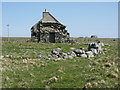
6
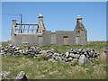
Ruined house at Arnol
The left-hand portion still has a roof on Google Earth 2009 imagery.
Image: © M J Richardson
Taken: 27 May 2016
0.22 miles
7
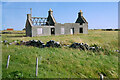
Houses at Arnol
The nearer building is considerably smarter than seen on Google Earth imagery from 2009, and is marked as a place of worship on the map.
Image: © M J Richardson
Taken: 27 May 2016
0.23 miles