IMAGES TAKEN NEAR TO
Sealladh A Chliseim, ISLE OF LEWIS, HS2 9AB
Introduction
This page details the photographs taken nearby to Sealladh A Chliseim, HS2 9AB by members of the Geograph project.
The Geograph project started in 2005 with the aim of publishing, organising and preserving representative images for every square kilometre of Great Britain, Ireland and the Isle of Man.

There are currently over 7.5m images from over14,400 individuals and you can help contribute to the project by visiting https://www.geograph.org.uk
Image Map (Loading...)


Getting Data...Please wait
Leaflet Map data © OpenStreetMap
Images are licensed for reuse under creativecommons.org/licenses/by-sa/2.0
Notes
- Clicking on the map will re-center to the selected point.
- The higher the marker number, the further away the image location is from the centre of the postcode.
Image Listing (1 Images Found)
Images are licensed for reuse under creativecommons.org/licenses/by-sa/2.0
Image
Details
Distance
1
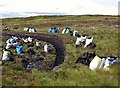
Peat cutting
Peat is still used as a fuel in the Outer Hebrides, although fewer people go to the effort of cutting it nowadays. This picture shows some peats still drying in stacks, and more already bagged up ready to be taken back home.
Image: © Eileen Henderson
Taken: 3 Jul 2007
0.08 miles