IMAGES TAKEN NEAR TO
St. Ronans Drive, ISLE OF LEWIS, HS2 0XD
Introduction
This page details the photographs taken nearby to St. Ronans Drive, HS2 0XD by members of the Geograph project.
The Geograph project started in 2005 with the aim of publishing, organising and preserving representative images for every square kilometre of Great Britain, Ireland and the Isle of Man.

There are currently over 7.5m images from over14,400 individuals and you can help contribute to the project by visiting https://www.geograph.org.uk
Image Map
Images are licensed for reuse under creativecommons.org/licenses/by-sa/2.0
Notes
- Clicking on the map will re-center to the selected point.
- The higher the marker number, the further away the image location is from the centre of the postcode.
Image Listing (4 Images Found)
Images are licensed for reuse under creativecommons.org/licenses/by-sa/2.0
Image
Details
Distance
1
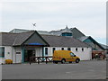
Lionel School / Sgoil Lionail
Modern community school serving Lional, Eoropaidh, An Cnoc Ard etc.
Image: © Gordon Hatton
Taken: 16 Jul 2007
0.16 miles
2
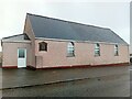
Ness Church (Free Presbyterian Church of Scotland)
An active church.
Image: © David Bremner
Taken: 18 Apr 2024
0.21 miles
3
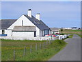
Old Police Station, by Eoropaidh
On a minor road, heading north to Eoropaidh / Eoropie village, the end of the road.
Image: © Colin Smith
Taken: 26 Jul 2011
0.23 miles
4
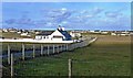
The Decca Restaurant
The Decca is the building in the foreground, located near Eoropie and Coig Peighinnean on the Isle of Lewis.
Image: © Mary and Angus Hogg
Taken: 28 Oct 2018
0.23 miles