IMAGES TAKEN NEAR TO
High Street, ISLE OF LEWIS, HS2 0TS
Introduction
This page details the photographs taken nearby to High Street, HS2 0TS by members of the Geograph project.
The Geograph project started in 2005 with the aim of publishing, organising and preserving representative images for every square kilometre of Great Britain, Ireland and the Isle of Man.

There are currently over 7.5m images from over14,400 individuals and you can help contribute to the project by visiting https://www.geograph.org.uk
Image Map (Loading...)


Getting Data...Please wait
Leaflet Map data © OpenStreetMap
Images are licensed for reuse under creativecommons.org/licenses/by-sa/2.0
Notes
- Clicking on the map will re-center to the selected point.
- The higher the marker number, the further away the image location is from the centre of the postcode.
Image Listing (4 Images Found)
Images are licensed for reuse under creativecommons.org/licenses/by-sa/2.0
Image
Details
Distance
1
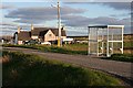
Bus Shelter at Sgiogarstaigh
Close to the end of the road, and probably not used very frequently.
Image: © Anne Burgess
Taken: 2 Jun 2009
0.01 miles
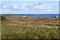
2
Sgiogarstaidh
The setting sun catches the red roof and white walls of cottages at Sgiogarstaidh. It looks as if the same scene had caught another contributor's eye: Image
Image: © Anne Burgess
Taken: 2 Jun 2009
0.19 miles
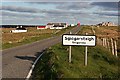
3
Sgiogarstaigh View
A chilly October view looking toward the buildings of Sgiogarstaigh.
Image: © Mary and Angus Hogg
Taken: 28 Oct 2018
0.20 miles
4
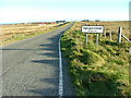
Road to Sgiogarstaigh
Another settlement in the district of Nis.
Image: © Dave Fergusson
Taken: 29 Sep 2007
0.21 miles