IMAGES TAKEN NEAR TO
Cross Skigersta Road, ISLE OF LEWIS, HS2 0TH
Introduction
This page details the photographs taken nearby to Cross Skigersta Road, HS2 0TH by members of the Geograph project.
The Geograph project started in 2005 with the aim of publishing, organising and preserving representative images for every square kilometre of Great Britain, Ireland and the Isle of Man.

There are currently over 7.5m images from over14,400 individuals and you can help contribute to the project by visiting https://www.geograph.org.uk
Image Map
Images are licensed for reuse under creativecommons.org/licenses/by-sa/2.0
Notes
- Clicking on the map will re-center to the selected point.
- The higher the marker number, the further away the image location is from the centre of the postcode.
Image Listing (5 Images Found)
Images are licensed for reuse under creativecommons.org/licenses/by-sa/2.0
Image
Details
Distance
1
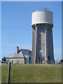
Ness Water Tower
The village water storage facility at Adabrock. There is an identical tower at the other side of Ness.
Image: © Donald Lawson
Taken: 22 Jul 2006
0.14 miles
2

Airigh Linngail
Croft cottages line the road at Airigh Linngail.
Image: © Anne Burgess
Taken: 2 Jun 2009
0.14 miles

4
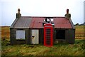
Former post office at Adabroc
Further decay has set in over the four years since John Allan photographed it Image - particularly to the corrugated iron section of the roof. The telephone box, though still marked as a facility on the current mapping and apparently containing its equipment, was inaccessible as the door had warped or jammed. For a glimpse of the interior see Image
Image: © Tiger
Taken: 22 Oct 2014
0.18 miles
5
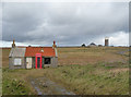
Old cottage at Adabroc crossroads
The Nis water tower can be seen on the horizon.
Image: © John Allan
Taken: 20 Oct 2010
0.18 miles